Pinnacles National Park
Pinnacles National Park in central California's Gabilan Mountains preserves 26,606 acres of dramatic volcanic landscape born from fire and sculpted by time. One of America's newest national parks, officially designated in 2013 after more than a century as a national monument, Pinnacles protects the eroded remnants of an ancient volcano that has traveled 195 miles from its original location through the slow but relentless movement of the San Andreas Fault. The park's towering rock spires, mysterious talus caves, and diverse ecosystems create a unique wilderness experience unlike any other in the National Park System.
The park's defining characteristic is its geological story of migration and transformation. Twenty-three million years ago, volcanic eruptions created the Pinnacles-Neenach Volcanic Field near present-day Lancaster, California. Over millennia, the Pacific Plate has carried the western half of this ancient volcano northward along the San Andreas Fault, separating it from its eastern counterpart (the Neenach Formation) and creating the dramatic landscape visitors see today. This ongoing tectonic journey, continuing at 1.5 inches per year, makes Pinnacles a living laboratory for understanding plate tectonics and geological processes.
Key Highlights
- Migrating Volcano: Ancient volcano split by San Andreas Fault
- Talus Caves: Unique boulder caves formed by rockfall
- California Condors: Critical recovery site for endangered birds
- High Peaks Trail: Spectacular rock formations and "Steep and Narrow"
- Two Districts: East and West sides with no connecting road
- Rock Climbing: World-class routes on volcanic breccia
- Chaparral Ecosystem: Mediterranean climate biodiversity
- Dark Night Skies: Minimal light pollution stargazing
Getting There
Pinnacles National Park has two separate entrances with no road connecting them within the park.
East Entrance (More Popular)
From Hollister (32 miles)
- Take Highway 25 south
- 45-minute scenic drive
- Access to visitor center and campground
- Open 24 hours for trail access
From San Jose (90 miles)
- Take US-101 south to Highway 25
- 2-hour drive
- Major metropolitan area access
- Weekend traffic considerations
West Entrance (More Remote)
From Soledad (14 miles)
- Take Highway 146 east
- 20-minute drive through vineyards
- Daylight hours only (7:30 AM - 8:00 PM)
- Quieter, more scenic approach
From Salinas (40 miles)
- Take US-101 south to Highway 146
- 1-hour drive
- Alternative coastal access
- Less crowded entrance
Important Access Notes
No Through Road
- East and West entrances not connected
- 90-minute drive between sides
- Plan full day for each district
- Different experiences available
GPS Reliability Issues
- Some GPS systems provide incorrect directions
- Verify routes on park website
- Paper maps recommended as backup
- Rural area with limited cell service
Gateway Communities
Hollister
- Full services and lodging
- Closest major town to East entrance
- Shopping and restaurants
- Medical facilities available
Soledad
- Limited services
- Historic mission town
- Basic accommodations
- Agricultural community
Best Time to Visit
Pinnacles' Mediterranean climate creates distinct seasonal patterns that dramatically affect the visitor experience.
Spring: March-May
Peak Season
- Temperatures: 65-80°F days, 40-55°F nights
- Spectacular wildflower displays
- Over 80% of plants in bloom
- Pleasant hiking conditions
- Busiest period
Fall: September-October
Excellent Alternative
- Temperatures: 70-85°F days, 45-60°F nights
- Clear, stable weather
- Fewer crowds after Labor Day
- Comfortable for all activities
- Second-best season
Winter: November-February
Solitude Season
- Temperatures: 50-65°F days, 30-45°F nights
- Occasional frost and light snow
- Rainy season (most precipitation)
- Minimal crowds
- Cool-weather hiking
Summer: June-August
Extreme Heat Warning
- Temperatures regularly exceed 100°F
- Can reach 115°F+
- Dangerous hiking conditions
- Early morning activity only
- Strongly discouraged for hiking
Weather Considerations
Mediterranean Climate
- Hot, dry summers
- Cool, wet winters
- Extreme daily temperature swings
- Limited shade on trails
- Fire danger in dry seasons
The Two Districts
Understanding the park's divided nature is essential for planning your visit.
East District: The Hub
The more developed and accessible side, containing the main visitor center and park's only campground.
Primary Attractions
- Bear Gulch Cave system
- Condor Gulch Trail
- High Peaks access
- Bear Gulch Reservoir
- Moses Spring Trail
Facilities
- Pinnacles Visitor Center
- Pinnacles Campground (134 sites)
- Bear Gulch Nature Center
- Swimming pool (seasonal)
- Camp store and showers
Advantages
- 24-hour trail access
- More amenities and services
- Better for overnight visitors
- Family-friendly facilities
West District: The Wilderness
The quieter, more remote side offering solitude and different trail experiences.
Primary Attractions
- Balconies Cave system
- Chaparral Picnic Area
- Juniper Canyon Trail
- West Pinnacles scenery
- Machete Ridge views
Facilities
- West Pinnacles Visitor Contact Station
- Picnic areas and restrooms
- Limited services
- No camping or lodging
Advantages
- Less crowded
- More wilderness feel
- Scenic vineyard approach
- Different cave experience
Activities and Adventures
Pinnacles offers diverse outdoor experiences centered around its unique geology and ecosystems.
Signature Hiking Experiences
High Peaks Trail Loop (5.3 miles, strenuous)
- Classic Pinnacles experience
- 1,300 feet elevation gain
- Famous "Steep and Narrow" section
- Metal handholds and carved steps
- 360-degree panoramic views
- Prime condor viewing area
Bear Gulch Cave Trail (2.2 miles, moderate)
- Talus cave exploration
- Flashlight required
- Seasonal closures (May-July for bats)
- Underground creek and pools
- Historic CCC stonework
- Bear Gulch Reservoir endpoint
Balconies Cave Trail (2.4 miles, moderate)
- West side cave system
- More primitive cave experience
- Boulder scrambling required
- Generally open year-round
- Headlamp essential
- Less crowded alternative
Juniper Canyon Trail (4.3 miles, strenuous)
- West side High Peaks access
- 1,215 feet elevation gain
- Steep ascent through chaparral
- Connects to High Peaks system
- Challenging but rewarding
Rock Climbing
Pinnacles offers world-class climbing on unique volcanic breccia rock.
Climbing Characteristics
- Volcanic breccia (weaker than granite)
- Traditional "ground-up" ethic
- No power drill use allowed
- Test holds carefully
- Friable rock requires caution
Popular Areas
- East Side: Tourist Trap, Discovery Wall, Upper Crust
- West Side: Machete Ridge, multi-pitch routes
- Difficulty Range: 5.2 to 5.13
- Seasonal Closures: January-July (raptor nesting)
Conservation Requirements
- Voluntary seasonal closures
- Protect nesting raptors
- Traditional climbing ethics
- No fixed anchors without permits
Wildlife Viewing
California Condor Viewing
- Best locations: High Peaks Trail, Condor Gulch Overlook
- Prime times: Early morning and evening
- Current population: 90+ free-flying birds
- Identification: Wingspan 9+ feet, white triangles under wings
- Binoculars essential
Other Wildlife
- 400+ bee species (world biodiversity hotspot)
- 14 bat species in talus caves
- Northern Pacific rattlesnakes
- Mountain lions and bobcats
- 160+ bird species
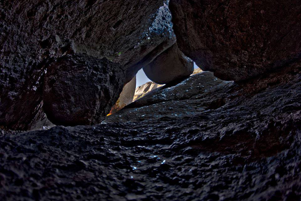
Cave Exploration
Safety Requirements
- Flashlight or headlamp mandatory
- Check cave status before visiting
- Cell phone lights inadequate
- Wear sturdy footwear
- Stay on designated routes
Bear Gulch Cave
- Larger, more developed system
- Seasonal bat colony protection
- Upper and lower sections
- Water features seasonally
- CCC-built staircases
Balconies Cave
- More primitive experience
- Boulder scrambling required
- Generally open year-round
- Shorter but challenging
- Less visitor traffic
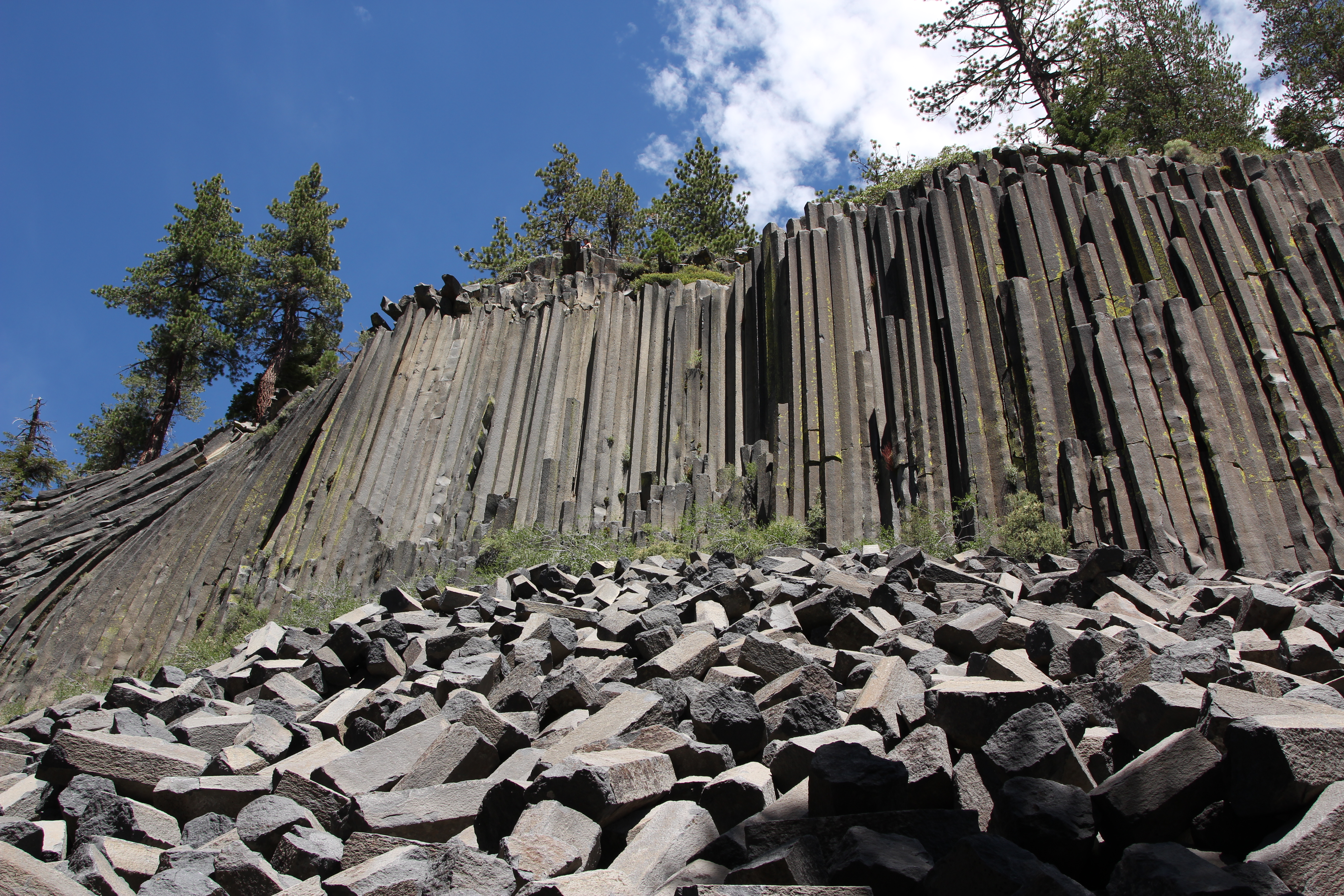
Geological Wonders
The Volcanic Story
Ancient Origins
- Formed 23 million years ago
- Originally near Lancaster, CA
- Volcanic breccia composition
- Weaker rock enables erosion
- Creates dramatic spires
Tectonic Journey
- San Andreas Fault bisects park
- Pacific Plate carries western half north
- 195 miles traveled from origin
- Ongoing movement at 1.5 inches/year
- Neenach Formation remains at origin
Erosion Sculpting
- Wind and water carving
- Freeze-thaw cycles
- Seismic activity effects
- Ongoing landscape changes
- Creates pinnacles and canyons
Talus Cave Formation
Mechanical Origins
- Ice Age rockfall events
- Earthquake-triggered slides
- Boulders wedged in canyons
- Natural roof formation
- No chemical dissolution
Cave Characteristics
- Dark, stable temperatures
- Seasonal water flow
- Critical bat habitat
- Unique hiking experience
- Requires artificial lighting
Ecosystems and Wildlife
Chaparral Dominance
Plant Community (82% of park)
- Mediterranean climate adaptation
- Fire-dependent ecosystem
- Drought-resistant species
- Dense shrub growth
- Small, waxy leaves
Key Species
- Chamise (dominant shrub)
- Manzanita varieties
- Buck brush
- Ceanothus species
- Deep-rooted adaptations
Other Habitats
Oak Woodlands (10%)
- Blue oak communities
- Grassy understories
- Wildlife corridors
- Seasonal green-up
- Acorn production areas
Riparian Zones
- Sycamores and cottonwoods
- Critical water sources
- Disproportionate wildlife value
- California red-legged frog habitat
- Seasonal flow patterns
Grasslands
- Fire-created openings
- Native bunch grasses
- Wildflower displays
- Seasonal color changes
- Grazing history visible
Conservation Success Stories
California Condor Recovery
Program Highlights
- Release site since 2003
- 90+ free-flying birds managed
- Each bird individually tracked
- GPS and radio monitoring
- Critical to species survival
Visitor Impact
- World-class wildlife viewing
- Conservation education
- Success story demonstration
- Ongoing research visible
- Citizen science opportunities
Fire Management
Prescribed Burns
- Used since 1970s
- Chaparral ecosystem health
- Fuel load reduction
- Natural process restoration
- Fire adaptation benefits
Lodging and Camping
In-Park Accommodations
Pinnacles Campground (East District Only)
- 134 total sites
- Tent and RV accommodations
- Group camping available
- Seasonal swimming pool
- Showers and restrooms
- Camp store
- Reservations essential (Recreation.gov)
- Book up to 6 months ahead
Gateway Area Lodging
Hollister Area
- Holiday Inn Express & Suites
- Fairfield Inn & Suites
- Various motels and B&Bs
- 45 minutes to East entrance
- Full services available
Soledad Area
- Motel 6 Soledad
- Limited options
- Basic accommodations
- 20 minutes to West entrance
- Agricultural community
King City
- Quality Inn King City
- Additional chain options
- 45 minutes to West entrance
- More dining choices
Essential Information
Park Fees and Hours
- Vehicle Pass: $30 (7 days)
- Motorcycle: $25
- Individual: $15
- Annual Pass: $55
- Cashless park (cards only)
Operating Hours
- East Entrance: 24 hours (trail access)
- West Entrance: 7:30 AM - 8:00 PM
- Visitor Centers: 9:00 AM - 4:00 PM (East), 9:00 AM - 3:00 PM (West)
Safety Considerations
Heat-Related Dangers
- Extreme summer temperatures
- Limited shade on trails
- Dehydration risk high
- Early morning hiking essential
- One liter water per hour minimum
Cave Safety
- Flashlight/headlamp required
- Check cave status online
- Slippery conditions possible
- Flash flood potential
- Stay on designated routes
Wildlife Precautions
- Northern Pacific rattlesnakes present
- Stay on trails
- Watch hand and foot placement
- Never feed wildlife
- Mountain lion habitat
Plant Hazards
- Poison oak common
- "Leaves of three" identification
- Grows as shrub or vine
- Seasonal appearance changes
- Immediate washing if contact
What to Bring
Essential Gear
- Extra water (critical in summer)
- Sun protection (hat, sunscreen, sunglasses)
- Sturdy hiking boots
- Flashlight for caves
- First aid supplies
- Map and trail guide
Seasonal Additions
- Summer: Cooling towels, electrolytes, pre-dawn start
- Winter: Warm layers, rain gear
- Spring/Fall: Camera for wildflowers and wildlife
- Year-round: Binoculars for condor viewing
Special Regulations
Cave Access
- Bear Gulch Cave closed mid-May to mid-July (bat protection)
- Upper cave sections may have additional closures
- Check current status on park website
- Flashlights mandatory for safety
Climbing Restrictions
- Seasonal raptor closures (January-July)
- Traditional ethics required
- No power drill use
- Check current closures before climbing
Fire Restrictions
- No open fires except in campground
- Smoking prohibited on trails
- High fire danger seasons
- Follow all posted restrictions
Pinnacles National Park offers a unique window into the dynamic forces that shape our planet, where visitors can witness geology in motion and conservation in action. This landscape of towering spires and hidden caves, born from volcanic fire and sculpted by millions of years of patient erosion, provides sanctuary for some of North America's most endangered species while challenging visitors with its rugged beauty. Whether exploring the mysterious talus caves, climbing the iconic rock formations, or watching California condors soar above the High Peaks, Pinnacles rewards those who come prepared with experiences found nowhere else on Earth. Plan for the park's divided nature, respect its harsh environment, and prepare to discover why this geologically young but visually ancient landscape represents one of California's most extraordinary natural treasures.
Real satellite imagery on NASA elevation — orbit the peaks at true scale.
Explore in 3D →What the park will quietly do to you.
Heat & Sun
SummerSummer highs can hit 100°F+ in many western parks. Carry 2 L of water per person minimum and avoid strenuous activity 10am–4pm.
Wildlife
Year-roundKeep 100 yards from bears and wolves, 25 from everything else. Never feed wildlife — it changes their behavior and ends with the animal euthanized.
Weather windows
SummerHigh-country thunderstorms build fast in summer afternoons. Plan to be off exposed ridges by noon, especially July–September.
Permits & timed entry
Plan aheadSeveral parks require timed-entry reservations or wilderness permits. Reserve weeks ahead via recreation.gov — same-day windows are limited.
Hero photo: National Park Service/Oscar Garcia