Death Valley National Park
Located across eastern California and southern Nevada, Death Valley National Park encompasses America's most extreme landscape. This vast 3.4-million-acre preserve holds multiple North American records: the continent's hottest, driest, and lowest point. Rather than being a lifeless wasteland, as its ominous name suggests, Death Valley supports remarkable biodiversity and offers visitors an otherworldly desert experience featuring salt flats, towering peaks, and pristine night skies.
Badwater Basin represents the park's most famous feature, lying 282 feet below sea level at North America's lowest elevation. The Timbisha Shoshone people, who have inhabited this region for over 1,000 years, called it Tümpisa meaning "rock paint," reflecting their understanding of the valley as a place of resources rather than desolation. Today, this Gold Tier International Dark Sky Park protects over 1,000 plant species and specialized wildlife adapted to survive in one of Earth's harshest environments.
Must-See Attractions
- Badwater Basin Salt Flats: North America's lowest point featuring unique crystalline formations
- Zabriskie Point: Golden hour viewpoint showcasing eroded badlands and colorful geology
- Artist's Palette: Rainbow-hued hillsides painted by mineral oxidation
- Mesquite Flat Sand Dunes: Wind-sculpted dunes ideal for sunrise photography
- Dante's View: High-elevation panoramic overlook spanning the entire valley
- Racetrack Playa: Remote dry lakebed famous for its mysteriously moving boulders
- Ubehebe Crater: Massive volcanic explosion crater in the park's northern region
Getting There
Death Valley's isolated location requires careful route planning. The park maintains year-round accessibility, though summer visits demand extra precautions due to extreme heat. Multiple entrance points serve different regions of the park.
Primary Access Routes
From Las Vegas, Nevada (120 miles, 2 hours)
- Follow US-95 North to NV-373 West toward Death Valley Junction
- Continue west on CA-190 into the park
- Most convenient route for eastern park exploration
From Los Angeles Area (290 miles, 4.5 hours)
- Take I-5 North to CA-14 North through Antelope Valley
- Connect to US-395 North, then CA-190 East
- Western park access via Panamint Springs
From Central California (Fresno area, 200 miles, 3.5 hours)
- Use CA-99 South to CA-58 East to CA-14 North
- Continue to US-395 North and CA-190 East
- Alternative western approach
Airport Access
- Las Vegas McCarran International (LAS): 130 miles southeast, most convenient
- Los Angeles International (LAX): 300 miles southwest, major airline hub
- Fresno Yosemite International (FAT): 200 miles west, smaller regional option
Vehicle Requirements
- Reliable air conditioning system essential for safety
- All-terrain or heavy-duty tires recommended for backcountry exploration
- Full fuel tank mandatory before entering (limited, expensive fuel available inside)
- Emergency supplies including extra water, food, and repair tools
- 4WD required only for remote backcountry roads
Optimal Visiting Seasons
Death Valley's extreme climate creates distinctly different seasonal experiences. Summer temperatures routinely exceed 120°F (49°C), making winter through spring the preferred visiting period for most activities.
Winter Season: December-February
Advantages:
- Mild daytime temperatures (60-70°F)
- Cold nights requiring warm clothing (can drop below freezing)
- Minimal crowds providing solitary experiences
- Clear skies perfect for stargazing
- All low-elevation activities accessible
Considerations:
- Snow possible at higher elevations limiting mountain access
- Some facilities operate reduced hours
- Short daylight hours
Spring Season: March-May
Advantages:
- Comfortable temperatures (75-90°F) ideal for hiking
- Potential wildflower blooms during favorable conditions
- Extended daylight hours
- All park roads typically open
Considerations:
- Peak visitation creating crowds at popular sites
- Higher accommodation rates and limited availability
- Increasing heat by late May requiring earlier activity starts
Summer Season: June-September
Advantages:
- Lowest visitation numbers
- Reduced accommodation costs
- Unique opportunity to experience extreme heat
- Perfect conditions for night exploration
Considerations:
- Dangerous temperatures (115-125°F+) limiting outdoor activities
- Low-elevation hiking strongly discouraged after 10 AM
- Risk of heat-related medical emergencies
- Some campgrounds closed during peak heat
Fall Season: October-November
Advantages:
- Pleasant temperatures returning (80-95°F cooling to 70s)
- Moderate crowds
- Excellent conditions for backcountry driving
- Ideal camping weather
Considerations:
- Temperatures still hot early in season
- Limited accommodation availability during favorable weather periods
Adventures and Exploration
Death Valley's immense scale offers diverse experiences from accessible viewpoints to challenging backcountry adventures. The park's unique geology provides opportunities for scenic driving, hiking, photography, and astronomical observation.
Scenic Driving Routes
Artist's Drive Loop (9 miles)
- Spectacular one-way route through volcanic badlands
- Late afternoon lighting enhances vibrant mineral colors
- 25-foot vehicle length restriction due to narrow curves
- Artist's Palette provides the route's photographic highlight
Badwater Road (17 miles)
- Primary paved route accessing southern park attractions
- Connects Devil's Golf Course, Natural Bridge trailhead, and Badwater Basin
- Suitable for all vehicle types
- Multiple short walking opportunities
Titus Canyon Road (27 miles, 4WD required)
- Premier backcountry drive beginning in Nevada
- One-way route through narrow canyon narrows
- Passes abandoned mining town of Leadfield
- Requires high-clearance vehicle and desert driving experience
Hiking Opportunities
Easy Walks (Under 2 miles)
Badwater Basin Exploration
- Walk across famous salt flat polygons
- Distance varies based on personal preference
- Flat terrain suitable for all ages
- Best experienced during cooler morning or evening hours
Salt Creek Nature Trail (1 mile)
- Boardwalk through rare desert pupfish habitat
- Wheelchair accessible wooden pathway
- Optimal viewing February through May during fish spawning
- Interpretive signs explain unique ecosystem
Moderate Trails (2-5 miles)
Golden Canyon and Badlands Loop (4 miles)*
- Classic hike through colorful eroded formations
- Optional extension to Red Cathedral amphitheater
- Gradual elevation gain with spectacular geological views
- Best lighting conditions in morning hours
Mosaic Canyon (2.6 miles)
- Narrow canyon featuring polished marble-like walls
- Initial half-mile contains most impressive formations
- Some rock scrambling required beyond narrows
- Popular route near Stovepipe Wells
Challenging Adventures (5+ miles)
Telescope Peak Summit (14 miles)
- Highest point in Death Valley at 11,049 feet
- Strenuous 3,000+ foot elevation gain
- Panoramic views including Mount Whitney on clear days
- Snow conditions November through May requiring mountaineering skills
Photography Destinations
Zabriskie Point
- Iconic sunrise location overlooking golden badlands
- Easy roadside access with minimal walking
- Optimal lighting 30 minutes before to 1 hour after sunrise
- Parking fills quickly during peak season
Dante's View
- Elevated panoramic perspective of entire valley
- 5,475-foot elevation provides expansive vistas
- Excellent sunset photography opportunity
- Can view both lowest (Badwater) and highest (Telescope Peak) park points
Night Sky Photography
- Gold Tier International Dark Sky Park designation
- Mesquite Flat Sand Dunes offer 360-degree sky views
- Harmony Borax Works provides convenient Furnace Creek access
- New moon periods provide darkest conditions
Desert Wildlife and Ecosystems
Contrary to common perception, Death Valley hosts remarkable biodiversity across multiple elevation zones. From below sea level to alpine peaks, specialized creatures and plants have evolved extraordinary adaptations to survive extreme conditions.
Wildlife Adaptations
Large Desert Mammals
- Desert Bighorn Sheep: Master cliff climbers capable of surviving 30% body weight water loss
- Mountain Lions: Elusive cats inhabiting higher elevation ranges
- Coyotes: Vocal nighttime hunters adaptable to various desert conditions
- Feral Burros: Descendants of mining-era pack animals, now managed population
Specialized Small Animals
- Kangaroo Rats: Never require drinking water, obtaining moisture from dry seeds
- Desert Kit Foxes: Large ears provide heat dissipation and superior hearing
- Chuckwalla Lizards: Inflate bodies when threatened to wedge in rock crevices
- Sidewinder Rattlesnakes: Specialized sideways locomotion adapted for sand travel
Rare Aquatic Species
- Devils Hole Pupfish: World's rarest fish surviving in single 93°F limestone cavern
- Salt Creek Pupfish: Endemic species adapted to highly saline desert streams
- Both species represent incredible evolutionary specialization to extreme environments
Plant Communities by Elevation
Valley Floor (Below 1,000 feet)
- Pickleweed and salt grass around saline areas
- Creosote bush dominance on alluvial fans
- Mesquite groves near water sources
- Desert holly adapted to salty soils
Mid-Elevation Slopes (1,000-5,000 feet)
- Various cactus species including barrel and cholla
- Seasonal wildflower displays during favorable winters
- Desert shrub communities in protected canyons
Mountain Woodlands (5,000+ feet)
- Pinyon pine and juniper forests
- Ancient bristlecone pines on highest peaks
- Specialized alpine plant communities adapted to snow and cold
Ephemeral Wildflower Displays
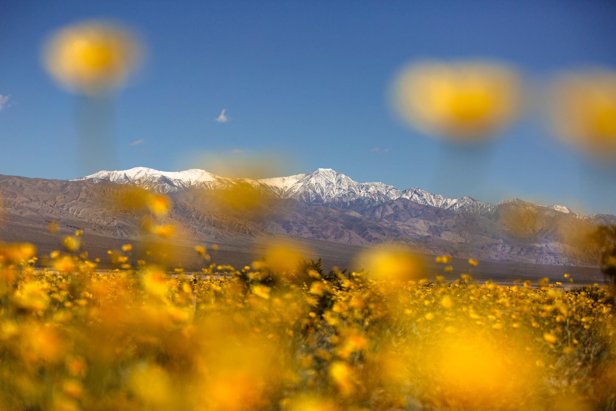
During rare winters with sufficient rainfall, Death Valley transforms into a spectacular floral display. Desert marigolds, ghost flowers, and evening primroses carpet the landscape in vibrant colors. These "superbloom" events occur unpredictably, typically peaking between late February and early April at lower elevations.
Lodging and Accommodation Options
Death Valley's remote location limits lodging choices, making advance reservations essential, particularly during favorable weather periods. Options range from historic luxury resorts to primitive backcountry camping under star-filled skies.
In-Park Lodging
The Oasis at Death Valley (Furnace Creek) Two distinct properties serve different needs:
The Inn at Death Valley
- Historic 1927 luxury resort with 88 rooms
- Full-service amenities including spa and fine dining
- World's lowest elevation golf course (-214 feet)
- Premium pricing reflecting historic significance and amenities
The Ranch at Death Valley
- Family-oriented lodging with 224 rooms
- Casual dining, general store, and recreational facilities
- More affordable alternative to The Inn
- Central location for exploring major attractions
Stovepipe Wells Village
- Rustic desert outpost near sand dunes
- Motel-style accommodations with western atmosphere
- On-site saloon, restaurant, and general store
- Convenient base for northern park exploration
Panamint Springs Resort
- Remote western park location offering solitude
- 15 rooms plus RV camping facilities
- Family-owned operation since 1960s
- Access to Darwin Falls and Joshua tree forests
Camping Facilities
Developed Campgrounds
Furnace Creek Campground
- 136 sites with flush toilets and water
- Reservations required October 15-April 15 (Recreation.gov)
- Date palm shade at select sites
- Central location near visitor center
Stovepipe Wells Campground
- 190 sites with basic facilities
- First-come, first-served basis
- Seasonal closure during extreme summer heat
- Close proximity to sand dunes
Backcountry Camping
- Free dispersed camping along dirt roads (minimum 1 mile from pavement)
- No facilities provided; complete self-sufficiency required
- Some high-use areas now require advance permits
- Popular locations include Racetrack area and Darwin Falls vicinity
External Accommodations
Beatty, Nevada (40 miles)
- Budget motels and RV parks
- Basic supplies and dining options
- Significantly lower costs than in-park lodging
Ridgecrest, California (75 miles)
- Full range of chain hotels and restaurants
- Complete supply shopping and medical facilities
- Major grocery stores and automotive services
Safety and Survival Guidelines
Death Valley's extreme environment demands respect and careful preparation. The park's isolation, extreme temperatures, and challenging terrain require visitors to prioritize safety and self-sufficiency.
Heat-Related Safety
Vehicle Preparedness
- Ensure air conditioning functions properly before entering
- Check coolant levels, belts, and hoses
- Maintain fuel tank above half full
- Carry emergency automotive supplies and tools
- Bring extra water for both drinking and vehicle cooling
Personal Protection Strategies
- Consume water regularly before feeling thirsty (minimum 1 gallon daily per person)
- Wear loose-fitting, light-colored clothing and wide-brimmed hats
- Apply sunscreen frequently, even during winter months
- Avoid outdoor activities during peak heat hours (10 AM-4 PM)
- Recognize heat exhaustion symptoms: heavy sweating, weakness, nausea
Medical Emergency Recognition Heat stroke represents a life-threatening emergency requiring immediate action. Symptoms include high body temperature, altered mental state, and hot, dry skin. Move victims to shade, cool with water, and seek emergency medical assistance immediately.
Remote Area Precautions
Communication and Navigation
- Cell phone service extremely limited throughout park
- Carry paper maps as GPS backup systems
- Inform others of detailed travel plans and expected return times
- Consider satellite communication devices for extended backcountry travel
Vehicle Breakdown Protocol
- Stay with vehicle providing shade and visibility to rescuers
- Signal for help using mirrors, bright clothing, or vehicle lights
- Conserve energy and water while awaiting assistance
- Avoid walking for help in extreme heat conditions
Wildlife Safety
Venomous Snake Encounters
- Watch foot and hand placement, especially around rocks
- Use flashlights during nighttime activities
- Wear closed-toe shoes and long pants when hiking
- Maintain distance if encountering snakes; seek immediate medical attention for any bite
Large Predator Awareness
- Make noise while hiking to avoid surprising mountain lions
- Store all food in hard-sided containers
- Never approach or feed any wildlife
- Back away slowly if encountering large predators
Flash Flood Risks
Desert storms can create sudden, dangerous flooding in canyons and low-lying areas. Check weather forecasts before entering narrow canyons, avoid camping in washes, and never attempt to drive through flowing water, regardless of apparent depth.
Emergency Resources
- Park Emergency: 911 or contact any park ranger
- Furnace Creek Visitor Center: (760) 786-2330
- Nearest Hospital: Ridgecrest Regional Hospital (75 miles)
- Park Entrance Fee: $30 per vehicle (7 days), cashless payments only
Death Valley National Park provides an unmatched opportunity to experience Earth's most extreme desert environment. Through proper preparation, safety awareness, and respect for the challenging conditions, visitors can safely explore this remarkable landscape and gain a profound appreciation for the adaptability of life in seemingly impossible circumstances.
Real satellite imagery on NASA elevation — orbit the peaks at true scale.
Explore in 3D →What the park will quietly do to you.
Heat & Sun
SummerSummer highs can hit 100°F+ in many western parks. Carry 2 L of water per person minimum and avoid strenuous activity 10am–4pm.
Wildlife
Year-roundKeep 100 yards from bears and wolves, 25 from everything else. Never feed wildlife — it changes their behavior and ends with the animal euthanized.
Weather windows
SummerHigh-country thunderstorms build fast in summer afternoons. Plan to be off exposed ridges by noon, especially July–September.
Permits & timed entry
Plan aheadSeveral parks require timed-entry reservations or wilderness permits. Reserve weeks ahead via recreation.gov — same-day windows are limited.
Hero photo: NPS