The Vertical Frontier
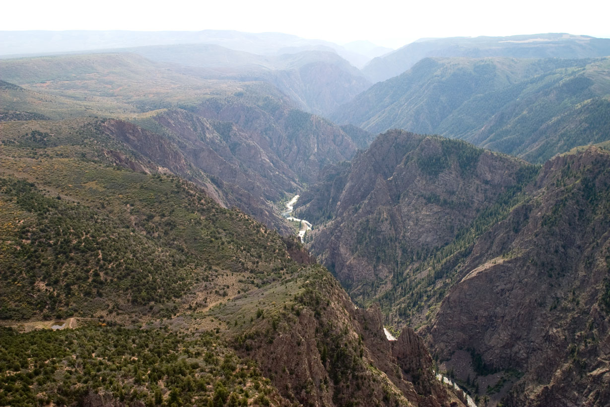
No canyon in North America combines the depth, narrowness, and sheer terror quite like Black Canyon of the Gunnison. This geological nightmare slices through Colorado's landscape—2,722 feet deep yet only 40 feet wide at its narrowest point. The walls are so steep and the gorge so narrow that parts of the canyon floor receive just 33 minutes of sunlight daily, creating the perpetual darkness that gives this chasm its name.
2025 Fire Impact Alert
CRITICAL UPDATE: Major wildfires in July 2025 have fundamentally altered park access:
South Rim Status
- CLOSED INDEFINITELY following extensive damage
- Visitor Center saved, but campground destroyed
- Multiple facilities and overlooks heavily damaged
- All reservations cancelled until further notice
North Rim Status
- REOPENED July 30, 2025
- Expect significantly increased visitation
- First-come camping only (13 sites)
- Limited ranger services available
Understanding Two Distinct Worlds
The Tale of Two Rims
With no bridges spanning the canyon, choosing your rim is crucial—driving between them takes 2+ hours.
South Rim (Currently Closed)
- Main park hub with paved access
- 12 developed overlooks
- Full visitor services (when open)
- 20 minutes from Montrose
- Best for families and first-timers
North Rim
- Remote wilderness experience
- 7-mile gravel road access
- 5 primitive overlooks
- 30 minutes from Crawford
- Ideal for solitude seekers
The Gunnison's Relentless Power
Geological Violence
The Gunnison River drops more elevation in 48 miles than the Mississippi does in 1,500 miles. This extreme gradient creates:
- 240-foot drop per mile at Chasm View
- 2-billion-year-old exposed rock
- Painted Wall: Colorado's tallest cliff at 2,250 feet
- 40-foot narrows imprisoning the river
Rock Types
- Precambrian gneiss and schist: Dark metamorphic base
- Pink pegmatite veins: Creating the "painted" patterns
- Volcanic breccia: From ancient eruptions
- River polish: Scoured smooth by millennia
Critical Terminology: Trails vs. Routes
Maintained Trails
Safe, marked paths along the rim:
- Warner Point Trail: 1.5 miles to deepest viewpoint
- Rim Rock Trail: 1 mile connecting campground to visitor center
- Oak Flat Loop: 1.6 miles below rim (moderate)
- Cedar Point Nature Trail: 0.3 miles (pet-friendly)
Wilderness Routes
NOT TRAILS—Extreme scrambles requiring:
- Free wilderness permit (mandatory)
- Route-finding skills (no markers)
- Self-rescue capability (no cell service)
- 80% grade in places (near-vertical)
- Poison ivy gauntlet at river level
Recommended gear
We may earn a commission from purchases made through links on this page. See our disclosure.
High Altitude Considerations
Elevation Facts
- Rim elevation: 8,000-8,700 feet
- River level: 5,500 feet
- Altitude sickness risk: Significant for sea-level visitors
- Oxygen levels: 25% less than sea level
Acclimatization Strategy
- Spend night in Montrose (5,800 feet)
- Hydrate aggressively (3+ liters daily)
- Avoid alcohol first 48 hours
- Limit exertion on arrival day
Seasonal Realities
Summer (June-August)
- Peak visitation (especially with South Rim closed)
- Afternoon thunderstorms common
- Temperatures: 80s°F rim, 90s°F canyon floor
- Aggressive deer protecting fawns
Fall (September-November)
- Ideal conditions for hiking
- Golden aspens in surrounding areas
- Cooler temperatures: 60s-70s°F
- Less crowded after Labor Day
Winter (December-March)
- North Rim closed entirely
- South Rim limited to visitor center area
- Cross-country skiing on closed roads
- Sub-zero temperatures possible
Spring (April-May)
- Wildflower blooms on rims
- Snowmelt runoff peaks
- Variable weather (snow to 70s°F)
- Road openings weather-dependent
Essential Activities
Rim Exploration
Classic Overlooks (when South Rim reopens):
- Gunnison Point: First view from visitor center
- Chasm View: Narrowest section perspective
- Painted Wall View: Colorado's highest cliff
- Warner Point: Deepest point (2,722 feet)
- Dragon Point: Prime sunset location
Photography Hotspots
- Dawn: East-facing walls illuminated
- Midday: Rare light reaching canyon floor
- Golden Hour: Painted Wall glows pink
- Night: Some of Colorado's darkest skies
Adventure Options
- Rock Climbing: 150+ traditional routes
- Kayaking: Expert-only Class V rapids
- Fishing: Gold Medal waters below East Portal
- Winter Sports: Snowshoeing and Nordic skiing
Wildlife and Natural Hazards
Wildlife Encounters
- Black bears: Present but rarely seen
- Mountain lions: Active dawn/dusk
- Mule deer: Aggressive during fawning season
- Golden eagles: Nesting on cliff faces
- Prairie rattlesnakes: Common at river level
Environmental Dangers
- Altitude sickness: Above 8,000 feet
- Lightning strikes: Exposed rim positions
- Rockfall: Constant freeze-thaw erosion
- Poison ivy: Thick at river level
- Dehydration: Low humidity accelerates
Planning Essentials
Gateway Towns
Montrose (20 minutes from South Rim):
- Full services and lodging
- Regional airport
- Grocery and gear shops
- Medical facilities
Crawford (30 minutes from North Rim):
- Limited services
- One general store
- Few lodging options
- Gas up in Hotchkiss
Costs
- Entrance Fee: $30/vehicle (7 days)
- Annual Pass: $55
- Camping: $18-36/night
- Wilderness Permit: Free (required)
- America the Beautiful Pass: Accepted
Essential Gear
- For Rim Viewing: Binoculars, layers, sun protection
- For Inner Canyon: Helmet, gloves, first aid, GPS
- For Photography: Wide-angle lens, tripod, filters
- For Camping: Bear containers, warm sleeping bag
Shuttle and guided tours
We may earn a commission from purchases made through links on this page. See our disclosure.
Visitor Strategies
With Limited Time (2-4 hours)
- Drive scenic rim road
- Stop at 3-4 major overlooks
- Walk Warner Point Trail
- Visit during golden hour
Full Day Visit
- Arrive at sunrise
- Hike Oak Flat Loop
- Explore all overlooks
- Attempt careful rim photography
- Picnic lunch with views
Multi-Day Adventure
- Camp at North Rim
- Obtain wilderness permit
- Attempt inner canyon route
- Explore both rim areas
- Night sky photography
Current Alternatives
With South Rim damage, consider:
- Curecanti National Recreation Area: Adjacent water recreation
- Crawford State Park: Nearby camping overflow
- Gunnison Gorge NCA: Downstream wilderness
- West Elk Wilderness: Backcountry hiking
Safety Priorities
Never Attempt
- Rim jumping or free climbing
- Inner canyon without permit
- Drone flights (federal crime)
- Off-trail rim exploration
- Swimming in river (Class V)
Always Remember
- Cell service nonexistent in canyon
- Rescue response time: Hours to days
- Weather changes rapidly
- Rockfall happens without warning
- Your safety is your responsibility
The Dark Canyon's Future
Black Canyon of the Gunnison stands as one of America's most intimidating natural features—a place where the earth opens to reveal its ancient basement rocks in a dizzying display of geological time. The 2025 fires have added a new chapter to this landscape's story, temporarily altering how visitors experience this vertical wilderness but not diminishing its raw power.
Whether gazing into the abyss from a safe overlook or descending the precipitous routes to the roaring river below, every visitor confronts the same reality: some places on Earth remain fundamentally wild, fundamentally dangerous, and fundamentally awe-inspiring. The Black Canyon is all three, demanding respect, preparation, and a healthy dose of caution from all who approach its shadowed depths.
Real satellite imagery on NASA elevation — orbit the peaks at true scale.
Explore in 3D →What the park will quietly do to you.
Heat & Sun
SummerSummer highs can hit 100°F+ in many western parks. Carry 2 L of water per person minimum and avoid strenuous activity 10am–4pm.
Wildlife
Year-roundKeep 100 yards from bears and wolves, 25 from everything else. Never feed wildlife — it changes their behavior and ends with the animal euthanized.
Weather windows
SummerHigh-country thunderstorms build fast in summer afternoons. Plan to be off exposed ridges by noon, especially July–September.
Permits & timed entry
Plan aheadSeveral parks require timed-entry reservations or wilderness permits. Reserve weeks ahead via recreation.gov — same-day windows are limited.
Hero photo: NPS Photo/Lynch