Canyonlands National Park
Canyonlands National Park in southeastern Utah encompasses 337,598 acres of high desert wilderness carved by the Colorado and Green Rivers into one of the most spectacular canyon systems in North America. Utah's largest national park preserves a landscape of extraordinary scale and diversity, where towering sandstone mesas, deep river canyons, and fantastically eroded rock formations create a geological masterpiece millions of years in the making. The park's defining characteristic is its division by the two great rivers into four distinct districts, each offering completely different experiences ranging from accessible scenic overlooks to some of the most remote wilderness in the continental United States.
Established in 1964 through the dedicated efforts of superintendent Bates Wilson, often called the "Father of Canyonlands," the park protects this pristine canyon country from development while providing access to its remarkable landscapes. The Colorado and Green Rivers serve as both the sculptors and the barriers of this terrain, creating natural boundaries that divide the park into Island in the Sky (accessible mesa-top viewing), The Needles (backcountry hiking paradise), The Maze (remote wilderness adventure), and The Rivers themselves (waterway exploration). No roads connect these districts within the park boundaries, making Canyonlands not one destination but four separate adventures, each requiring its own planning and approach.
Key Highlights
- Four Distinct Districts: Island in the Sky, Needles, Maze, and Rivers
- Mesa Arch: World-famous sunrise photography location
- White Rim Road: 100-mile backcountry driving adventure
- Chesler Park: Spectacular needle formations and grassland
- Cataract Canyon: Legendary whitewater rafting
- Great Gallery: Ancient rock art in Horseshoe Canyon
- Dark Sky Park: Gold-tier stargazing designation
- River Confluence: Meeting of Colorado and Green Rivers
Getting There
Each district requires separate planning and different approaches from gateway communities.
Island in the Sky District
From Moab (32 miles)
- Take US-191 north to UT-313
- 40-minute drive on paved roads
- Most accessible district
- Suitable for all vehicles
From Green River (54 miles)
- Take I-70 west to UT-24 south
- Connect to UT-313
- 1-hour drive
- Alternative approach
The Needles District
From Moab (75 miles)
- Take US-191 south to UT-211 west
- 90-minute drive, all paved
- Turn at Newspaper Rock
- Longer but scenic approach
From Monticello (49 miles)
- Take US-191 north to UT-211 west
- 1-hour drive
- Closer base community
- Limited services
The Maze District
From Green River (46 miles unpaved)
- Take UT-24 to dirt roads
- 2.5+ hours to Hans Flat Ranger Station
- High-clearance 4WD required
- Additional hours to reach canyons
GPS Warning
- GPS systems unreliable in remote areas
- Paper maps essential
- Frequently directs to impassable roads
- Local knowledge recommended
Gateway Communities
Moab
- Full services and amenities
- Adventure tour outfitters
- Hotels and restaurants
- Medical facilities
- Closest to Island in the Sky
Green River
- Limited services
- River trip staging area
- Basic accommodations
- Closest to Maze access
Monticello
- Small town services
- Closest to Needles
- Gas and supplies
- Quiet base option
Best Time to Visit
The high desert climate creates extreme seasonal variations that significantly impact accessibility and comfort.
Spring: April-May
Optimal Conditions
- Temperatures: 60-80°F days, 35-50°F nights
- Perfect hiking weather
- Wildflower blooms
- Comfortable camping
- Peak season begins
Fall: September-October
Ideal Season
- Temperatures: 65-85°F days, 40-55°F nights
- Clear, stable weather
- Excellent visibility
- Comfortable for all activities
- Peak visitation
Summer: June-August
Extreme Heat Challenges
- Temperatures exceed 100°F regularly
- Can reach 110°F+
- Dangerous hiking conditions
- Monsoon thunderstorms
- Flash flood risks
Winter: December-February
Cold Season Considerations
- Temperatures: 30-50°F days, 10-25°F nights
- Snow possible
- Road closures likely
- Limited services
- Extreme solitude
Weather Warnings
Year-Round Hazards
- Temperature swings of 40°F daily
- No shade in most areas
- Dehydration risk high
- Lightning danger during storms
- Flash floods in slot canyons
The Four Districts
Understanding each district is crucial for planning your Canyonlands experience.
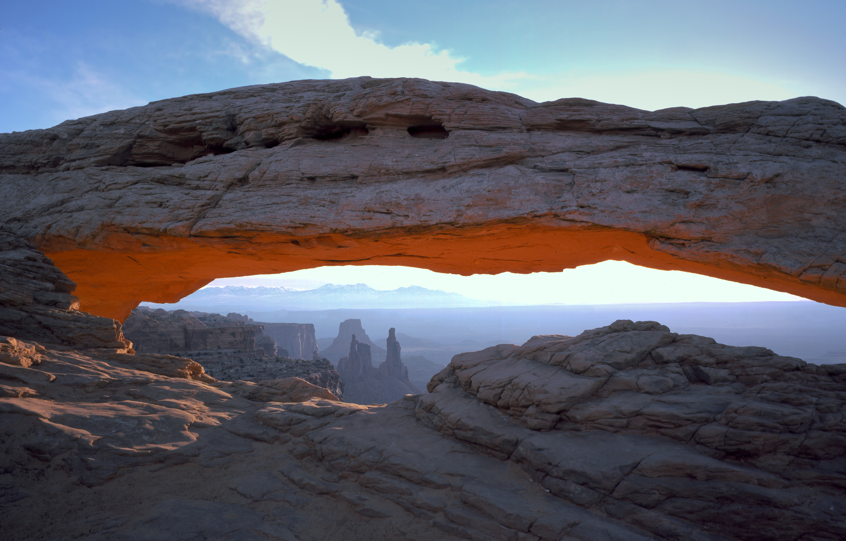
Island in the Sky: The Grand Balcony
The most accessible district perches 1,000 feet above the surrounding terrain, offering spectacular panoramic views from a massive sandstone mesa.
Scenic Drive (34 miles roundtrip)
- Grand View Point: Expansive canyon views
- Green River Overlook: Sunset location
- Shafer Canyon Overlook: White Rim Road preview
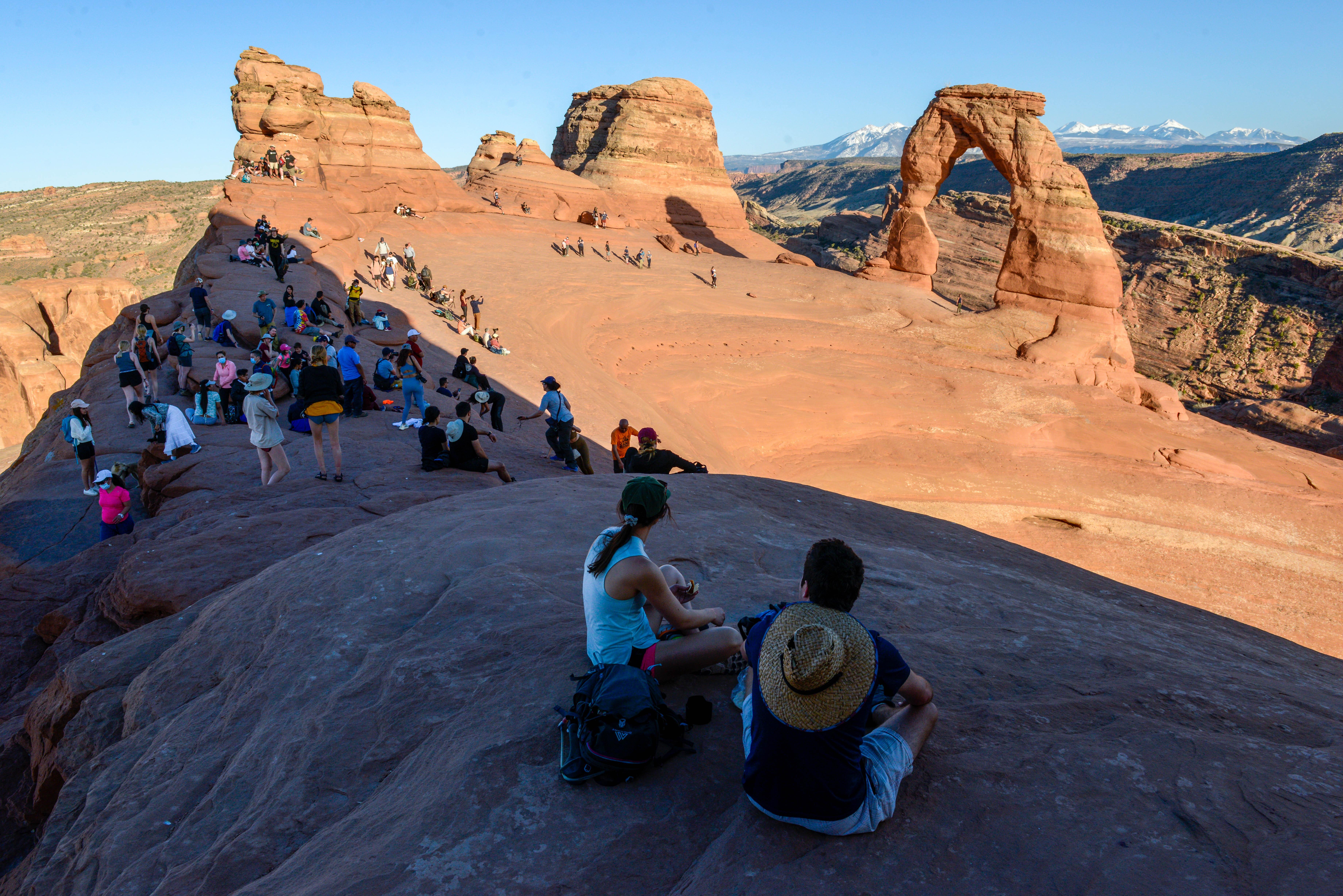
- Mesa Arch: Iconic sunrise spot
- Upheaval Dome: Mysterious geological formation
Essential Hikes
- Mesa Arch Trail: 0.6 miles, easy, sunrise photography
- Grand View Point Trail: 1.8 miles, easy, rim walking
- White Rim Overlook: 1.8 miles, moderate, Colorado River views
- Upheaval Dome Overlook: 0.6 miles, moderate, crater views
White Rim Road Access
- 100-mile backcountry driving loop
- 2-3 days required
- High-clearance 4WD necessary
- Permits required (book months ahead)
The Needles: Stone Forest
A backcountry paradise of red and white sandstone spires, perfect for serious hiking and backpacking adventures.
Signature Adventures
- Chesler Park Loop: 11 miles, strenuous, classic needle formations
- Joint Trail: Narrow slot canyon passages
- Druid Arch: 10.8 miles, strenuous, massive formation
- Confluence Overlook: 11 miles, strenuous, river meeting point
Backcountry Roads
- Elephant Hill: Technical 4WD challenge
- Salt Creek: Archaeological sites
- Lavender Canyon: Backcountry camping
- Horse Canyon: Remote exploration
Facilities
- Visitor center and museum
- Developed campground
- Backcountry campsites
- Group camping areas
The Maze: Remote Wilderness
The most challenging district offers true wilderness experience in one of America's most remote locations.
Access Requirements
- High-clearance, low-range 4WD mandatory
- Multiple days required
- Self-rescue capabilities essential
- No services whatsoever
Iconic Destinations
- Maze Overlook: First view into the labyrinth
- Land of Standing Rocks: Surreal formations
- The Doll House: Isolated spires
- Flint Trail: Notorious access road
Special Considerations
- Hans Flat Ranger Station contact required
- Detailed trip planning mandatory
- Emergency communication recommended
- Weather-dependent access
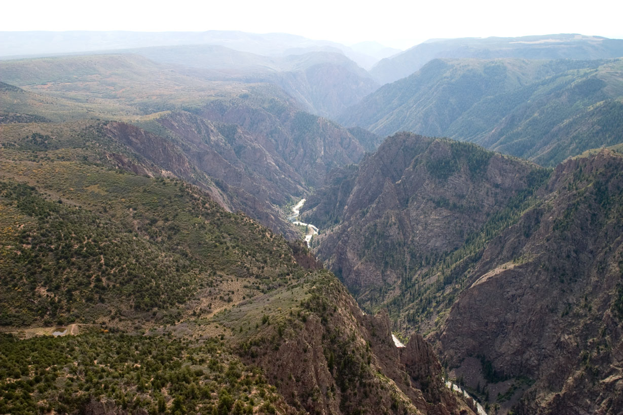
The Rivers: Liquid Highways
The Colorado and Green Rivers offer the only way to experience the park as a unified landscape.
Flatwater Sections
- Green River through Labyrinth Canyon
- Colorado River through Meander Canyon
- Multi-day trips recommended
- Spectacular canyon walls
Whitewater Adventure
- Cataract Canyon below Confluence
- Class III-V rapids
- Spring runoff most intense
- Commercial trips available
River Logistics
- Permits required for all trips
- Shuttle services necessary
- Multi-day commitment
- Professional guides recommended
Activities and Adventures
Canyonlands offers experiences from easy sightseeing to extreme wilderness challenges.
Hiking and Backpacking
Island in the Sky Trails
- Mesa Arch Loop: 0.6 miles, easy
- Grand View Point: 1.8 miles, easy
- Neck Spring: 5.8 miles, moderate
- Syncline Loop: 8.1 miles, strenuous
Needles District Trails
- Roadside Ruin: 0.3 miles, easy
- Cave Spring: 0.6 miles, easy
- Pothole Point: 0.6 miles, easy
- Big Spring Canyon: 7.5 miles, moderate
- Chesler Park: 11 miles, strenuous
Maze District Routes
- North Point: 14 miles, strenuous
- Maze Overlook: 3 miles, moderate
- Harvest Scene: 20+ miles, extreme
Four-Wheel Driving
Skill Level Requirements
Moderate (High-clearance 4WD)
- White Rim Road (Island in the Sky)
- Salt Creek Road (Needles)
- Horse Canyon (Needles)
Difficult (Low-range 4WD)
- Elephant Hill (Needles)
- Confluence Overlook Road (Needles)
Extreme (Expert drivers only)
- Flint Trail (Maze)
- Dollhouse Road (Maze)
- All Maze district roads
River Running
Commercial Outfitters
- Day trips and multi-day expeditions
- All skill levels accommodated
- Equipment and meals provided
- Professional guides
Private Trips
- Permits required
- Extensive planning necessary
- Self-supported expeditions
- Advanced skills recommended
Stargazing and Night Photography
Gold-Tier Dark Sky Park
- 15,000+ stars visible on clear nights
- Milky Way photography opportunities
- Ranger-led programs seasonally
- Best viewing locations at overlooks
Cultural and Natural History
Geological Story
Rock Formations
- Entrada Sandstone (mesa caps)
- Navajo Sandstone (White Rim)
- Cedar Mesa Sandstone (Needles)
- Wingate Sandstone (cliff walls)
Formation Process
- 300 million years of deposition
- Uplift and tilting
- River carving over 6 million years
- Ongoing erosion processes
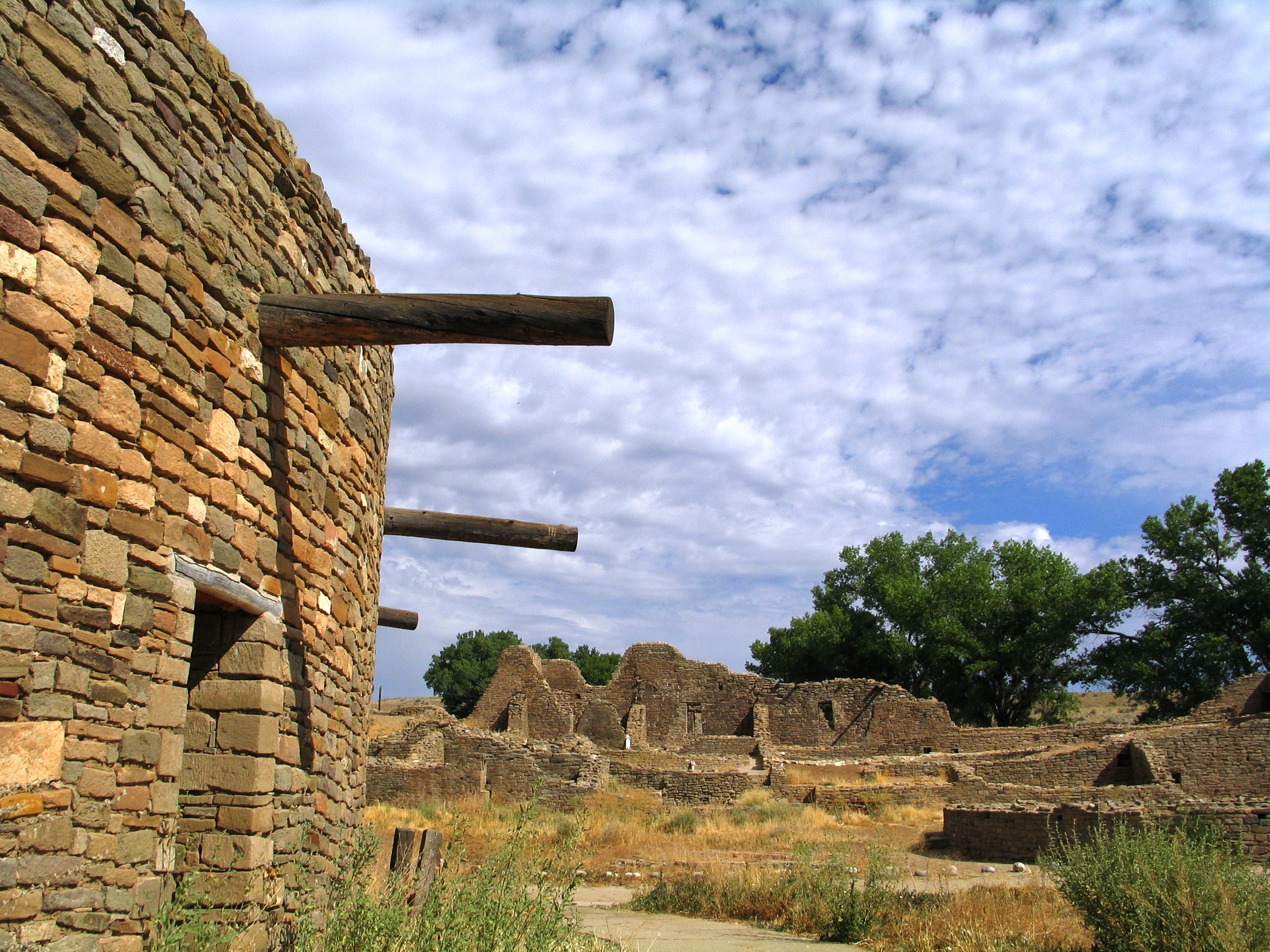
Human History
Ancient Peoples
- Archaic cultures (8,000+ years ago)
- Ancestral Puebloans (1,000+ years ago)
- Rock art panels throughout park
- Archaeological sites protected
Historic Era
- Cattle ranching (late 1800s)
- Uranium mining (1950s)
- Outlaw hideouts (Butch Cassidy)
- John Wesley Powell expeditions
Great Gallery (Horseshoe Canyon)
- Life-sized pictographs
- 2,000-4,000 years old
- Archaic culture artwork
- World-class rock art site
Wildlife and Ecology
Large Mammals
- Desert bighorn sheep
- Mule deer
- Mountain lions
- Coyotes
- Black bears (rare)
Desert Adaptations
- Kangaroo rats
- Desert cottontails
- Ringtails
- Kit foxes
Bird Life
- 273 recorded species
- Golden eagles
- Peregrine falcons
- Canyon wrens
- Pinyon jays
Plant Communities
- Pinyon-juniper woodlands
- Desert shrublands
- Riparian corridors
- Biological soil crusts
Lodging and Camping
In-Park Camping
Island in the Sky
- Willow Flat Campground: 12 sites
- First-come, first-served
- No hookups or showers
- Elevation 6,000 feet
The Needles
- Squaw Flat Campground: 26 sites
- Reservations recommended
- Group sites available
- Restrooms and water
Backcountry Camping
- Permits required
- Designated sites and at-large zones
- No facilities
- Leave No Trace principles
Gateway Lodging
Moab Area
- Full range of accommodations
- Luxury resorts to budget motels
- Vacation rentals
- RV parks and campgrounds
Monticello
- Limited hotel options
- Basic services
- Quiet alternative
- Family-owned establishments
Green River
- Budget accommodations
- River trip staging
- Historic railroad town
- Basic amenities
Essential Information
Park Fees
- Vehicle Pass: $30 (7 days)
- Motorcycle: $25
- Individual: $15
- Annual Pass: $55
- Interagency passes accepted
Visitor Centers
Island in the Sky Visitor Center
- Open year-round (weather permitting)
- Exhibits and film
- Book and map sales
- Trail information
Needles Visitor Center
- Open March-October
- Archaeological exhibits
- Backcountry permits
- Road conditions
Hans Flat Ranger Station (Maze)
- Open sporadically
- Essential for Maze visits
- Permits and information
- Emergency contact
Permits and Reservations
White Rim Road
- Day-use permits: $30 per vehicle
- Camping permits: $30 plus $15 per campsite
- Book 4 months in advance
- High demand for spring/fall
Backcountry Permits
- $30 per group plus $15 per campsite per night
- At-large zones: $30 per group per night
- Book up to 4 months ahead
- Walk-in permits sometimes available
River Permits
- Private trips: Varies by section
- Commercial trips: Book with outfitters
- Day-use permits available
- Seasonal availability
Safety Considerations
Desert Hazards
- Extreme temperature variation
- Limited water sources
- Venomous reptiles
- Flash flood potential
- Getting lost or stranded
Equipment Essentials
- Extra water (1 gallon per person per day)
- Sun protection
- First aid supplies
- Map and compass
- Emergency shelter
Vehicle Requirements
- Full fuel tank
- Spare tire and tools
- Recovery equipment for 4WD routes
- Extra water and food
- Communication device
Special Regulations
Resource Protection
- Stay on designated trails
- Camp only in designated areas
- No collecting or disturbing artifacts
- Protect biological soil crusts
Wilderness Ethics
- Leave No Trace principles
- Pack out all waste
- Respect wildlife
- Minimize campfire impacts
Canyonlands National Park represents canyon country at its most spectacular and challenging. This is not a park for casual touring but rather a destination for those seeking genuine wilderness adventure and the chance to experience landscapes largely unchanged since John Wesley Powell's pioneering river expeditions. Whether standing on the rim of Island in the Sky watching sunrise illuminate the distant La Sal Mountains, threading between towering needles in Chesler Park, navigating the technical challenges of the Maze, or floating through the silent depths of the river canyons, Canyonlands rewards those who come prepared with some of the most profound wilderness experiences available in the American Southwest. Plan carefully, respect the harsh environment, and prepare for landscapes that will fundamentally change your understanding of the power of water and time.
Real satellite imagery on NASA elevation — orbit the peaks at true scale.
Explore in 3D →What the park will quietly do to you.
Heat & Sun
SummerSummer highs can hit 100°F+ in many western parks. Carry 2 L of water per person minimum and avoid strenuous activity 10am–4pm.
Wildlife
Year-roundKeep 100 yards from bears and wolves, 25 from everything else. Never feed wildlife — it changes their behavior and ends with the animal euthanized.
Weather windows
SummerHigh-country thunderstorms build fast in summer afternoons. Plan to be off exposed ridges by noon, especially July–September.
Permits & timed entry
Plan aheadSeveral parks require timed-entry reservations or wilderness permits. Reserve weeks ahead via recreation.gov — same-day windows are limited.
Hero photo: NPS/Neal Herbert