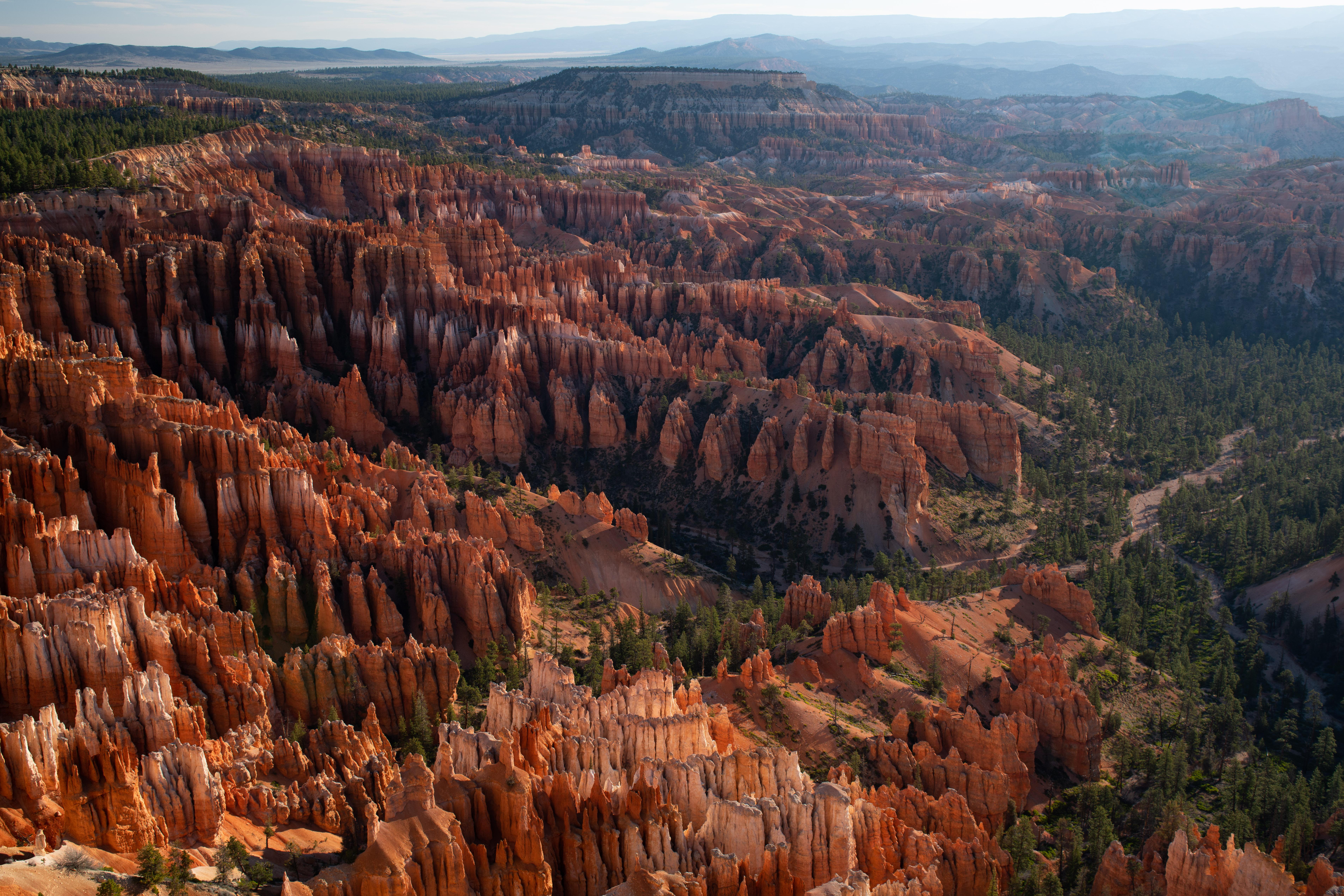
Bryce Canyon National Park: The 9,000-Foot Vertical Maze That Kills
Perched at lung-crushing altitudes where oxygen levels drop to 70% of sea level, Bryce Canyon National Park lures 2.4 million annual visitors into a deceptive vertical labyrinth of crumbling limestone spires that collapse without warning, killing through falls, altitude sickness, and exposure. This 56-square-mile death trap rises to 9,115 feet where summer afternoon thunderstorms turn the amphitheater into a lightning strike zone, while winter transforms trails into ice-covered slides with 1,000-foot drops. With hoodoo formations made of soft Claron limestone that crumbles like chalk underfoot, flash floods that sweep through narrow slot canyons, and temperatures that plunge 50°F after sunset, Bryce proves that Instagram-worthy views come with body-recovery price tags.
Essential Information at a Glance
- Size: 35,835 acres in southern Utah
- Established: February 25, 1928
- Annual Visitors: 2,461,269 (2023) - Growing rapidly
- Elevation Range: 6,620 feet to 9,115 feet (Rainbow Point)
- Entry Fee: $35 per vehicle (7 days), $20 per person
- Key Dangers: Altitude sickness, hoodoo collapses, lightning strikes, ice falls
- Temperature Swings: 40-50°F daily variations common
Survival Essentials: High-Altitude Desert Preparedness
The Oxygen Deprivation Equation
At 8,000+ feet, every step becomes harder. Your sea-level lungs work overtime. Heart rates spike. Dehydration accelerates. Altitude sickness strikes visitors daily, turning scenic hikes into medical emergencies when combined with steep climbs back OUT of the amphitheater.
Recommended gear: high altitude hiking
- Hiking Backpacksvia REI
- Trail Shoesvia Merrell
- Book Lodgingvia Booking.com
- Car Rentalsvia Rentalcars.com
We may earn a commission from purchases made through links on this page. See our disclosure.
Bryce Canyon Survival Arsenal
Altitude Adaptation Gear
- Pulse oximeter (monitor oxygen levels)
- Electrolyte replacement system
- Altitude sickness medication
- Extra water capacity (1 gallon minimum)
- Emergency oxygen canister
Lightning Protection
- Lightning detector device
- Emergency shelter (non-conductive)
- Insulated ground pad
- Metal-free rain gear
- GPS with storm tracking
Ice & Snow Equipment (Oct-May)
- Microspikes/crampons MANDATORY
- Trekking poles with carbide tips
- Ice axe for steep sections
- Avalanche beacon (backcountry)
- 4-season gear
Hoodoo Navigation Safety
- GPS with downloaded maps
- Physical map (phones fail)
- Emergency whistle
- High-visibility markers
- Headlamp with extra batteries
Death Zones: Bryce's Vertical Geography
The Amphitheater: Nature's Colosseum of Death
The main Bryce Amphitheater drops 1,000+ feet through a maze of fragile hoodoos. Every trail descending requires climbing back UP at altitude. The soft limestone crumbles underfoot. Getting lost among identical spires happens fast. No cell service below rim.
Wall Street: The Slot Canyon Squeeze
This narrow section of Navajo Loop closes entirely in winter due to ice falls and rockfall. Even when "open," the 200-foot walls funnel flash floods. Zero escape routes. Hikers get trapped between tour groups. Claustrophobia triggers panic.
Fairyland Loop: 8-Mile Altitude Suffocation
Marketed as scenic but kills through exhaustion. 2,300 feet of elevation change at 8,000+ feet. No water sources. Full sun exposure. Most rescues happen here when unprepared hikers collapse. "Loop" means no shortcuts back.
Peek-a-boo Loop: Horse Trail Horror
Sharing narrow trails with mule trains creates deadly situations. Thousand-pound animals have right-of-way on cliff edges. Step wrong avoiding them = 500-foot fall. Horse manure creates slip hazards. Dust clouds cause breathing problems.
Rainbow Point: 9,115-Foot Lightning Rod
Highest point in park = first lightning strike target. Afternoon storms arrive without warning. Temperature drops 30°F in minutes. Wind gusts exceed 60 mph. Ice forms on trails even in summer. Nearest shelter is 18 miles away.
Altitude Reality: The Invisible Killer
Oxygen Deprivation Statistics
- Sea Level: 100% oxygen availability
- 8,000 feet: 75% oxygen
- 9,000 feet: 70% oxygen
- Breathing Rate: Increases 40%
- Heart Rate: Spikes 20-40%
Altitude Sickness Progression
- Mild (6+ hours): Headache, nausea
- Moderate (12+ hours): Vomiting, confusion
- Severe (24+ hours): Pulmonary edema
- Fatal: High-altitude cerebral edema
- Treatment: Immediate descent
Dehydration Acceleration
- Lose 2x normal water through breathing
- Sweat evaporates instantly (don't notice)
- Kidney function increases
- Blood thickens dangerously
- Minimum 4 liters/day needed
Lightning Strike Zones
Afternoon Storm Pattern
Build Time: 12:00-2:00 PM Strike Time: 2:00-6:00 PM Clear Time: After 7:00 PM Safe Window: Before noon only Deaths: Multiple per decade
Strike Survival Protocol
- Below rim by noon (mandatory)
- Never highest object
- Avoid lone trees
- Lightning position if caught
- 30-30 rule (thunder/shelter)
High-Risk Locations
- Rim Trail (exposed 5.5 miles)
- Sunset Point overlook
- Rainbow Point summit
- Bristlecone Loop
- Any viewpoint after noon
Winter Death Trap (November-March)
Ice Statistics
- Trail Ice: 3-6 inches thick
- Temperature: -20°F possible
- Snow Depth: 5+ feet
- Visibility: Zero in storms
- Rescue Time: 6+ hours
Common Winter Deaths
- Slip on ice, fall 1,000 feet
- Hypothermia (underestimate cold)
- Lost in whiteout conditions
- Avalanche in backcountry
- Carbon monoxide in vehicles
Mandatory Winter Gear
- Microspikes/crampons (no exceptions)
- Multiple insulation layers
- Emergency bivy sack
- GPS beacon
- 48-hour survival supplies
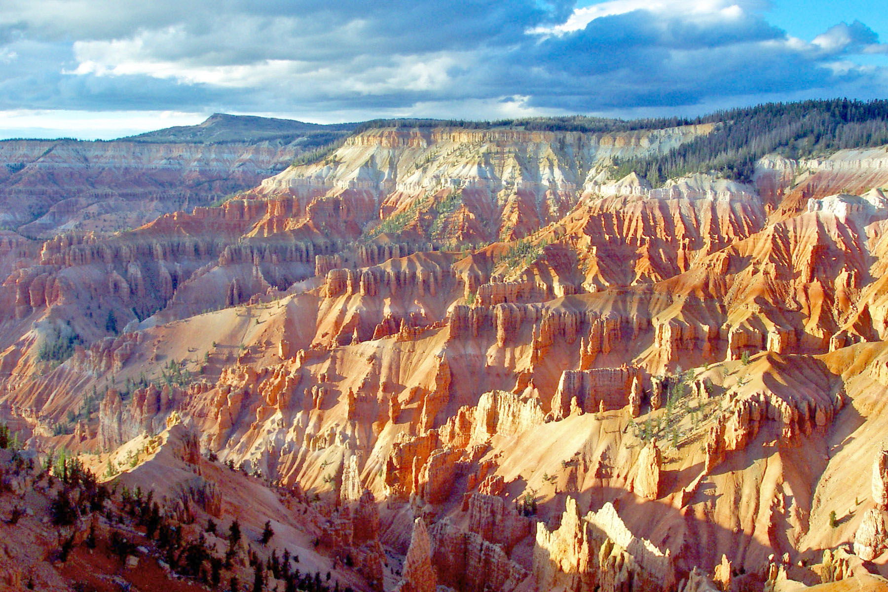
Hoodoo Hazards: Crumbling Death Spires
Claron Formation Facts
- Composition: Soft limestone/mudstone
- Stability: Crumbles when touched
- Erosion Rate: 2-4 feet/century
- Collapse Risk: Constant
- Off-trail: Immediate $500 fine
Fall Statistics
- Fatal falls occur annually
- Most from "shortcutting" trails
- Rock gives way without warning
- 100-1,000 foot drops common
- Recovery requires technical rescue
The Instagrammer's Demise
People die for photos by:
- Climbing hoodoos (collapse)
- Jumping gaps (miss/crumble)
- Rim dancing (wind gusts)
- Ignoring barriers (unstable edges)
- "Just one more step" syndrome
Flash Flood Alley
Monsoon Season (July-September)
- Daily afternoon thunderstorms
- 2 inches of rain in 20 minutes
- Slot canyons become deathtraps
- Water rises 10 feet in minutes
- Escape impossible
Flood Warning Signs
- Dark clouds anywhere (not just overhead)
- Distant thunder
- Muddy water trickling
- Debris in dry washes
- Animals fleeing uphill
Wildlife Encounters
Mountain Lions: 10-20 Invisible Stalkers
Territory: Entire park Hunt Pattern: Dawn/dusk ambush Prey Size: Includes adult humans Defense: Fight back aggressively Children: Keep very close
Prairie Dog Plague
Disease: Bubonic plague present Transmission: Flea bites Symptoms: Fever, swollen lymph nodes Treatment Window: 24 hours Prevention: Never approach burrows
Rattlesnakes: Rim and Canyon
Species: Great Basin rattlesnake Active: April-October Location: Sunny rocks, trails Strike Range: 2/3 body length Antivenom Cost: $50,000+
Seasonal Survival Guide
Spring (April-May): Deceptive Killer
Temperature: 30-70°F Hazards:
- Snow persists above 8,000 feet
- Ice on north-facing trails
- Extreme temperature swings
- Unpredictable storms
- Muddy trails = slip hazard
Summer (June-August): Peak Death Season
Temperature: 40-85°F Hazards:
- Daily lightning strikes
- Maximum crowds = accidents
- Altitude sickness epidemic
- Dehydration accelerated
- Flash flood season
Fall (September-October): Temperature Plunge
Temperature: 20-65°F Hazards:
- First ice appears
- 50°F temperature drops
- Earlier darkness
- Storm intensity increases
- Unprepared visitors
Winter (November-March): Ice Age
Temperature: -20-40°F Reality:
- Park becomes ice rink
- Visibility near zero
- Hypothermia in 30 minutes
- Roads close frequently
- Self-rescue only
Navigation & Emergency Reality
Communication Blackout
- Cell Service: Rim only (spotty)
- Below Rim: Zero coverage
- GPS: Downloads required
- Radio: No reception
- Rescue: Self-extraction critical
Getting Lost = Getting Dead
- Hoodoos look identical
- Trails fork constantly
- Cairns knocked over
- Panic leads off-trail
- Off-trail = fatal falls
Emergency Response
- Average Time: 2-4 hours
- Night Rescue: Next day
- Winter: Maybe impossible
- Cost: Your expense
- Helicopter: Weather dependent
Cost Reality Check
Entrance & Camping
- 7-Day Vehicle Pass: $35
- Annual Bryce Pass: $70
- North Campground: $30/night
- Sunset Campground: $30/night
- Backcountry Permit: $10 + $5/person
Gateway Lodging
- Bryce Canyon Lodge: $280+/night
- Bryce Canyon City: $110-200/night
- Tropic (10 miles): $130-200/night
- Panguitch (25 miles): $60-150/night
Hidden Costs
- Microspikes rental: $15/day
- Altitude sickness treatment: $500+
- Rescue costs: $5,000-25,000
- Shuttle: Free but limited
- Rim dining: $20-40/meal
Park Regulations & Fines
Prohibited Actions (Fines up to $5,000)
- Climbing hoodoos
- Shortcutting trails
- Collecting rocks/fossils
- Drone operation
- Feeding wildlife
Required Equipment
- Traction devices (winter)
- Bear-proof food storage
- Leashed pets (paved areas only)
- Backcountry permits
- Proper footwear
10 Commandments of Bryce Survival
- Altitude Kills Slowly - Acclimate or evacuate
- Down Is Optional, Up Is Mandatory - Energy for return climb
- Lightning Owns Afternoon - Below rim by noon
- Ice Means Spikes - No exceptions October-May
- Hoodoos Crumble - Stay on trail or die
- Water Disappears Fast - 1 gallon minimum
- Temperature Plunges 50°F - Layer or freeze
- Rim Has No Railings - Wind gusts kill
- Rescue Isn't Guaranteed - Self-sufficiency required
- Pretty Means Deadly - Instagram vs. survival
Final Reality Check
Bryce Canyon's fairy-tale landscape of orange and pink hoodoos masks a high-altitude death trap where beauty and lethality intertwine at every viewpoint. Those whimsical rock spires aren't playground equipment—they're crumbling gravestones waiting to mark your fall. The altitude that creates those stunning clear views also starves your brain of oxygen while you attempt steep climbs. Every descent into the amphitheater requires double the energy to climb back out, and there's no water, shade, or cell service below the rim. Summer afternoon lightning turns the exposed rim into an electric death zone. Winter ice transforms every trail into a thousand-foot sliding board. The park's compact size fools visitors into underestimating its dangers, but this vertical maze kills through altitude, dehydration, lightning, ice, and gravity with ruthless efficiency. Come prepared with proper gear, deep respect for elevation, and the wisdom to turn back before that perfect photo becomes your final photo.
Real satellite imagery on NASA elevation — orbit the peaks at true scale.
Explore in 3D →What the park will quietly do to you.
Heat & Sun
SummerSummer highs can hit 100°F+ in many western parks. Carry 2 L of water per person minimum and avoid strenuous activity 10am–4pm.
Wildlife
Year-roundKeep 100 yards from bears and wolves, 25 from everything else. Never feed wildlife — it changes their behavior and ends with the animal euthanized.
Weather windows
SummerHigh-country thunderstorms build fast in summer afternoons. Plan to be off exposed ridges by noon, especially July–September.
Permits & timed entry
Plan aheadSeveral parks require timed-entry reservations or wilderness permits. Reserve weeks ahead via recreation.gov — same-day windows are limited.
Hero photo: NPS Photo / Peter Densmore