Capitol Reef National Park
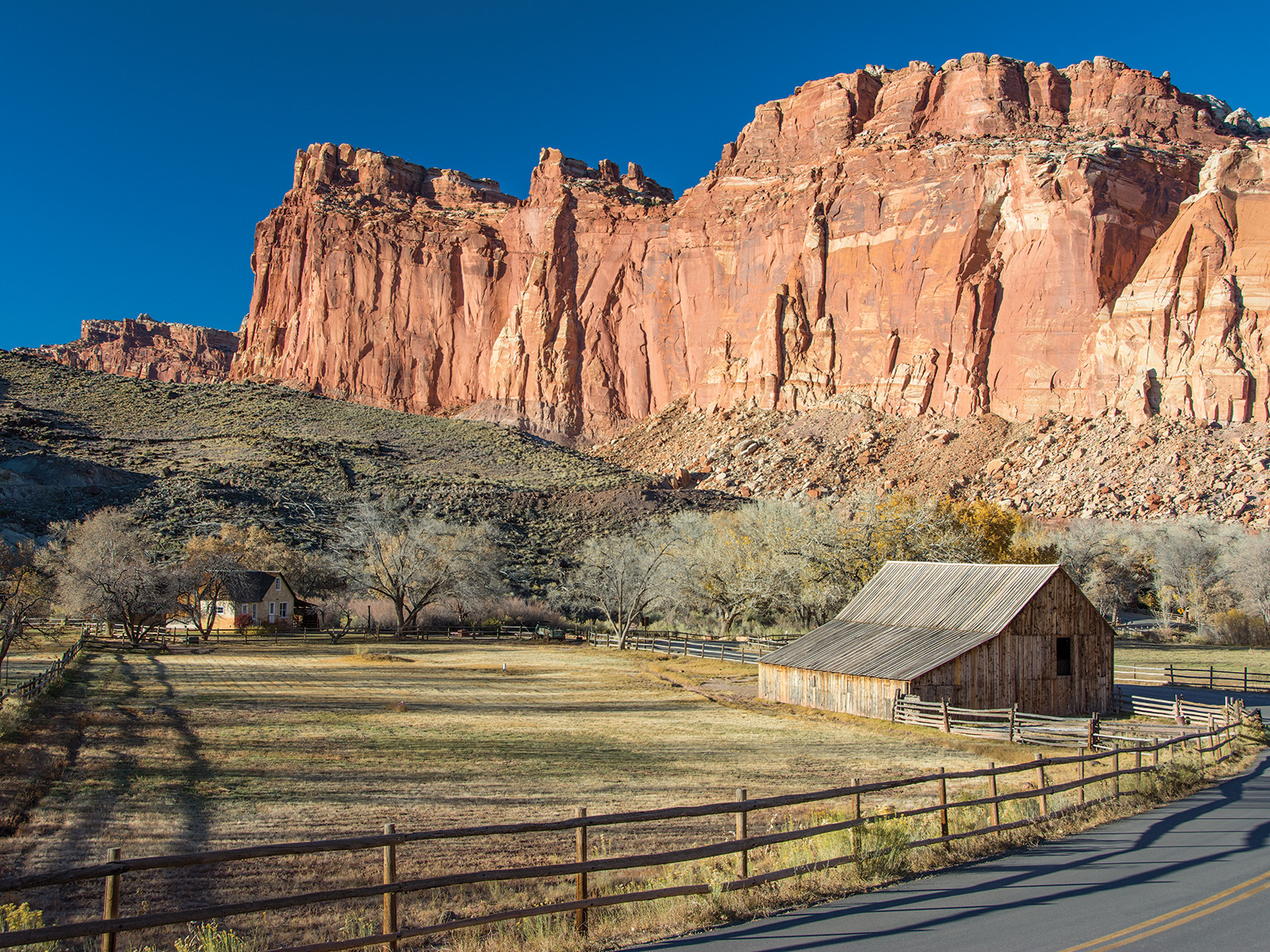
Capitol Reef National Park protects a spectacular wrinkle in Earth's crust known as the Waterpocket Fold, a 100-mile-long monocline that creates one of the most geologically dramatic landscapes in the American West. This hidden gem of Utah's red rock country showcases nearly 10,000 feet of sedimentary strata, exposing 200 million years of Earth's history in vivid layers of red, white, orange, and purple rock. Unlike its more famous neighbors, Capitol Reef offers profound solitude and the chance to explore a landscape where ancient petroglyphs, pioneer orchards, and towering sandstone cliffs tell intertwining stories of geological forces and human adaptation.
The park takes its unusual name from two distinct features: the white domes of Navajo Sandstone that reminded early travelers of the U.S. Capitol building, and the formidable rock barrier that pioneers found as challenging to cross as an ocean reef. This massive geological uplift, created during the same mountain-building event that formed the Rocky Mountains 50-70 million years ago, continues to shape every aspect of the visitor experience today. From the accessible oasis of the Fruita Historic District to the remote backcountry of Cathedral Valley and the southern Waterpocket District, Capitol Reef rewards those who venture beyond the highway with some of Utah's most spectacular and uncrowded landscapes.
Key Highlights
- Waterpocket Fold: Largest exposed monocline in North America stretching 100 miles
- Fruita Historic District: Pioneer settlement with 3,000 fruit trees still producing
- Cathedral Valley: Remote district with massive sandstone monoliths
- Capitol Gorge: Historic pioneer route with inscriptions from 1871
- Petroglyphs: Fremont Culture rock art panels dating from 300-1300 CE
- International Dark Sky Park: Some of the darkest night skies in the country
- Hickman Bridge: Natural bridge spanning 133 feet
- Scenic Drive: 8-mile paved route through dramatic geology
Getting There
Capitol Reef's remote location in south-central Utah means careful planning is essential for your visit.
From Salt Lake City (217 miles)
Via I-15 and US-89
- Take I-15 South to Spanish Fork
- Exit onto US-6 East through Price
- Connect to US-191 South to I-70
- Exit at Highway 24 West
- 3.5-4 hours driving time
Scenic Alternative via US-89
- Take I-15 South to US-89
- Follow through Sanpete Valley
- Connect to Highway 24 at Sigurd
- 4-4.5 hours but more scenic
From Las Vegas (366 miles)
Via I-15 and I-70
- Take I-15 North to I-70 East
- Exit at Highway 24 West
- Pass through Hanksville
- 5-5.5 hours driving time
From Denver (520 miles)
Via I-70 West
- Take I-70 West through Colorado
- Continue through Green River, Utah
- Exit at Highway 24 West
- 7.5-8 hours driving time
Gateway Towns
Torrey
- 11 miles west of visitor center
- Primary lodging and services
- Restaurants and gas stations
- Last supplies before park
Teasdale
- 15 miles west of visitor center
- Quiet alternative to Torrey
- Limited services
- B&Bs and cabins
Transportation Notes
Vehicle Requirements
- Standard vehicles fine for main areas
- High-clearance 4WD for backcountry
- No public transportation available
- Rental cars recommended
Seasonal Road Conditions
- Highway 24 open year-round
- Backcountry roads impassable when wet
- Cathedral Valley requires river ford
- Check conditions at visitor center
Best Time to Visit
Capitol Reef's high desert climate creates distinct seasonal experiences with dramatic temperature variations.
Spring: March-May
Peak Season
- Mild temperatures (55-75°F)
- Spectacular orchard blossoms
- Perfect hiking weather
- Significant crowds
- Parking fills by 10 AM
Natural Events
- March-April: Apricot and cherry blossoms
- April-May: Apple and pear blossoms
- Wildflower displays
- Full river flows
Summer: June-August
Hot and Stormy
- Daytime highs 85-95°F+
- Monsoon season July-September
- Flash flood danger high
- Early morning hiking essential
- Fruit ripening begins
Monsoon Warnings
- Afternoon thunderstorms common
- Never enter slot canyons with storm threat
- Flash floods occur without warning
- Check weather before any hike
Fall: September-October
Ideal Conditions
- Pleasant temperatures (60-80°F)
- Apple harvest season
- Cottonwood colors
- Return of crowds
- Perfect backpacking weather
Harvest Schedule
- Early September: Peaches
- September-October: Apples and pears
- U-Pick program active
- Call fruit hotline: 435-425-3791
Winter: November-February
Solitude Season
- Cold nights (20-30°F)
- Mild days (40-50°F)
- Minimal crowds
- Possible snow at elevation
- Limited services
Winter Benefits
- Photography light exceptional
- Hiking still possible most days
- True wilderness experience
- Easy parking everywhere
Activities and Adventures
The park offers experiences from easy scenic drives to challenging backcountry expeditions.
Scenic Drives
Highway 24 (Free)
- 13 miles through park
- No entrance fee required
- Petroglyphs viewpoint
- Behunin Cabin
- Goosenecks Overlook
- Panorama Point
Capitol Reef Scenic Drive
- 8 miles one-way (16 round trip)
- $20 vehicle fee required
- Grand Wash access
- Capitol Gorge road
- Spectacular cliff views
- Self-guided geology tour
Cathedral Valley Loop
- 57.6-mile backcountry loop
- High-clearance 4WD required
- River ford at beginning
- Temple of the Sun/Moon
- Bentonite Hills
- 6-8 hours driving time
Burr Trail Loop
- 124-mile scenic backway
- Partially paved/dirt road
- Spectacular switchbacks
- Strike Valley Overlook
- Connects to Boulder
- Full day adventure
Hiking Trails
Easy Walks
- Sunset Point: 0.8 miles, panoramic views
- Petroglyphs: 0.2 miles boardwalk to rock art
- Goosenecks: 0.2 miles to overlook
Moderate Hikes
- Hickman Bridge: 1.8 miles, 400 feet gain, natural bridge
- Grand Wash: 4.4 miles, flat canyon walk
- Capitol Gorge: 2 miles, pioneer inscriptions and tanks
- Cohab Canyon: 3.4 miles, 440 feet gain, hidden canyon
Strenuous Hikes
- Cassidy Arch: 3.4 miles, 845 feet gain, walk atop arch
- Rim Overlook: 4.6 miles, 1,110 feet gain, expansive views
- Golden Throne: 4 miles, 730 feet gain, golden cliff views
- Navajo Knobs: 9.5 miles, 1,650 feet gain, highest viewpoint
Backcountry Routes
- Lower Muley Twist: 15-mile canyon trek
- Upper Muley Twist: 9-mile loop with arches
- Halls Creek Narrows: Multi-day expedition
- Pleasant Creek: Remote canyon exploration
Special Programs
Fruita Orchards
- 3,000 historic fruit trees
- U-Pick program (small fee)
- Living history demonstrations
- Harvest season activities
- Gifford Homestead pies
Dark Sky Programs
- Ranger-led astronomy
- Annual Heritage Starfest
- Best viewing locations provided
- Milky Way visible most nights
Geology Tours
- Ranger-guided walks
- Self-guided auto tours
- Junior Ranger program
- Evening amphitheater talks
Wildlife and Natural Features
Capitol Reef's diverse elevations and habitats support surprising biodiversity in the high desert.
Geological Wonders
Rock Formations
- Navajo Sandstone domes
- Wingate Sandstone cliffs
- Chinle Formation colors
- Morrison Formation hills
- Entrada Sandstone temples
Unique Features
- Waterpockets (natural cisterns)
- Tafoni (honeycomb weathering)
- Desert varnish streaks
- Gypsum sinkhole
- Volcanic boulders
Wildlife
Large Mammals
- Desert bighorn sheep
- Mountain lions (rare)
- Mule deer
- Kit foxes
- Ringtail cats
Birds
- Golden eagles
- Peregrine falcons
- Pinyon jays
- Canyon wrens
- White-throated swifts
Reptiles
- Midget faded rattlesnake
- Collared lizards
- Whiptail lizards
- Great Basin gopher snake
Plant Life
Desert Adaptations
- Utah juniper
- Pinyon pine
- Prickly pear cactus
- Mormon tea
- Cryptobiotic soil crusts
Riparian Zones
- Fremont cottonwoods
- Willows
- Box elder
- Historic fruit trees
- Hanging gardens
Lodging and Camping
Limited accommodations make advance planning essential, especially March through October.
In-Park Camping
Fruita Campground
- 71 sites along river
- Flush toilets, water
- No showers or hookups
- $25/night
- Reservations required (Recreation.gov)
- Books 6 months ahead
Cathedral Valley Campground
- 6 primitive sites
- 7,000 feet elevation
- Pit toilet, no water
- Free, first-come
- High-clearance access only
Cedar Mesa Campground
- 5 primitive sites
- 5,500 feet elevation
- Pit toilet, no water
- Free, first-come
- Easier access than Cathedral
Gateway Lodging
Torrey Options
- Hotels: $80-150/night
- Motels: $60-100/night
- B&Bs: $100-200/night
- Vacation rentals available
- Restaurants and services
Teasdale Lodging
- Cabins: $100-250/night
- Historic inns
- Quieter than Torrey
- Limited dining options
Dispersed Camping
BLM Lands
- Free camping allowed
- Outside park boundaries
- No facilities
- 14-day limit
- Leave No Trace essential
Essential Information
Park Fees
- Vehicle Pass: $20 (7 days)
- Motorcycle: $15
- Individual: $10
- Annual Pass: $40
- America the Beautiful accepted
- Highway 24 viewing free
Safety Warnings
Flash Flood Danger
- Primary hazard in park
- Check weather always
- Never enter narrow canyons with storm threat
- Floods occur miles from rain
- Escape to high ground immediately
Desert Hazards
- Carry 1 gallon water per person/day
- No water in backcountry
- Extreme summer heat
- Hypothermia risk in winter
- Cell service extremely limited
Road Safety
- Dirt roads impassable when wet
- Cathedral Valley requires river crossing
- Steep grades and switchbacks
- RVs restricted on many roads
What to Bring
Essential Gear
- Extra water and food
- Sun protection
- First aid kit
- Map and compass
- Emergency shelter
Seasonal Items
- Summer: Electrolytes, cooling towels
- Winter: Warm layers, ice traction
- Monsoon: Weather radio
- Spring/Fall: Layers for temperature swings
Visitor Services
Visitor Center
- Open daily (except holidays)
- Exhibits and film
- Ranger information
- Permits and passes
- Gift shop and bookstore
Limited Services
- No gas in park
- No food services (except pie shop)
- No lodging in park
- Nearest hospital 70 miles
- Plan to be self-sufficient
Special Considerations
Permits Required
- Overnight backpacking
- Commercial photography
- Special use activities
- Group size limits apply
Leave No Trace
- Pack out all trash
- Stay on designated trails
- Don't disturb artifacts
- Respect cryptobiotic soil
- Camp only in designated areas
Capitol Reef National Park offers an extraordinary journey through deep time where colorful rock layers tell stories spanning hundreds of millions of years. This hidden treasure provides solitude seekers with uncrowded trails, dark night skies, and the chance to pick fruit from historic orchards planted by Mormon pioneers. Whether you're walking through narrow slot canyons, gazing at thousand-year-old petroglyphs, or watching sunset paint the Capitol domes gold, this park rewards those who venture beyond the highway with experiences found nowhere else. Come prepared for desert conditions, respect the power of flash floods, and discover why Capitol Reef remains one of America's best-kept national park secrets.
Real satellite imagery on NASA elevation — orbit the peaks at true scale.
Explore in 3D →What the park will quietly do to you.
Heat & Sun
SummerSummer highs can hit 100°F+ in many western parks. Carry 2 L of water per person minimum and avoid strenuous activity 10am–4pm.
Wildlife
Year-roundKeep 100 yards from bears and wolves, 25 from everything else. Never feed wildlife — it changes their behavior and ends with the animal euthanized.
Weather windows
SummerHigh-country thunderstorms build fast in summer afternoons. Plan to be off exposed ridges by noon, especially July–September.
Permits & timed entry
Plan aheadSeveral parks require timed-entry reservations or wilderness permits. Reserve weeks ahead via recreation.gov — same-day windows are limited.
Hero photo: NPS Photo