Zion National Park: Utah's Slot Canyon Death Trap
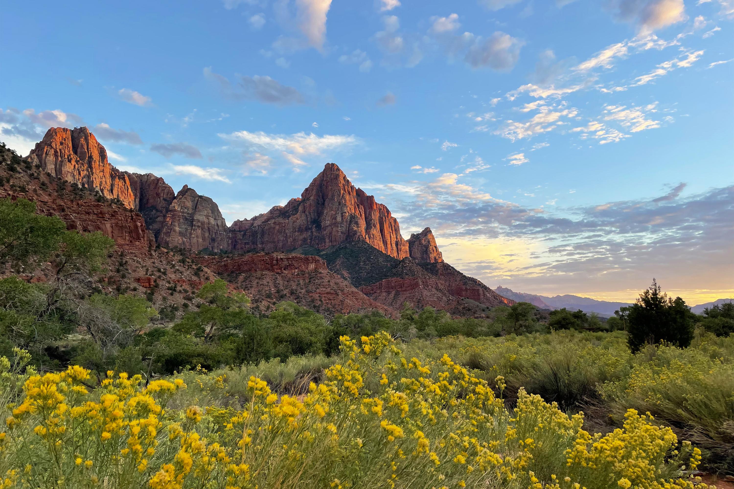
Rising from the Utah desert like towering cathedral spires, Zion National Park's 2,000-foot sandstone cliffs create one of America's most spectacular—and treacherous—landscapes. With 4.9 million annual visitors, this red rock paradise ranks as the nation's second-most-visited park, but its narrow slot canyons have claimed more lives through flash floods than almost any other national park. The Virgin River that carved these magnificent gorges continues to kill unprepared hikers who underestimate the power of desert flash floods.
Essential Information at a Glance
- Size: 147,237 acres in southwestern Utah
- Established: November 19, 1919
- Annual Visitors: 4,946,592 (2023) - #2 most visited national park
- Elevation Range: 3,666 feet (Virgin River) to 8,726 feet (Horse Ranch Mountain)
- Entry Fee: $35 per vehicle (7 days), $30 motorcycle, $20 individual
- Shuttle System: Mandatory March-October (private vehicles banned)
- Key Danger: Flash floods in slot canyons, extreme heat exposure
Survival Essentials: Desert Canyon Preparedness
The Flash Flood Factor: Death from Above
Zion's narrow slot canyons become deadly funnels during flash floods. Rain 50+ miles upstream can create wall-to-wall water in The Narrows within minutes. More people die from drowning in Zion than from any other cause.
Recommended gear: flash flood survival
- Hiking Backpacksvia REI
- Trail Shoesvia Merrell
- Book Lodgingvia Booking.com
- Car Rentalsvia Rentalcars.com
We may earn a commission from purchases made through links on this page. See our disclosure.
Slot Canyon Survival Kit
Narrows-Specific Gear (Life-Saving)
- Waterproof dry bag for emergency items
- Neoprene socks and quick-dry pants (hypothermia prevention)
- Grippy river shoes or boots (not tennis shoes)
- Trekking pole or walking stick for river balance
- Emergency whistle (floods can separate groups)
Desert Heat Protection
- Wide-brimmed hat with chin strap (slot canyon winds)
- UPF 50+ long-sleeve shirt and pants
- Minimum 1 gallon water per person (3+ liters in summer)
- Electrolyte replacement tablets
- Cooling towels for neck and wrists
Emergency Gear
- NOAA weather radio for flash flood warnings
- Emergency space blanket (hypothermia risk in wet conditions)
- Waterproof first aid kit
- High-energy snacks (sugar for hypothermia treatment)
- Cell phone in waterproof case (limited service)
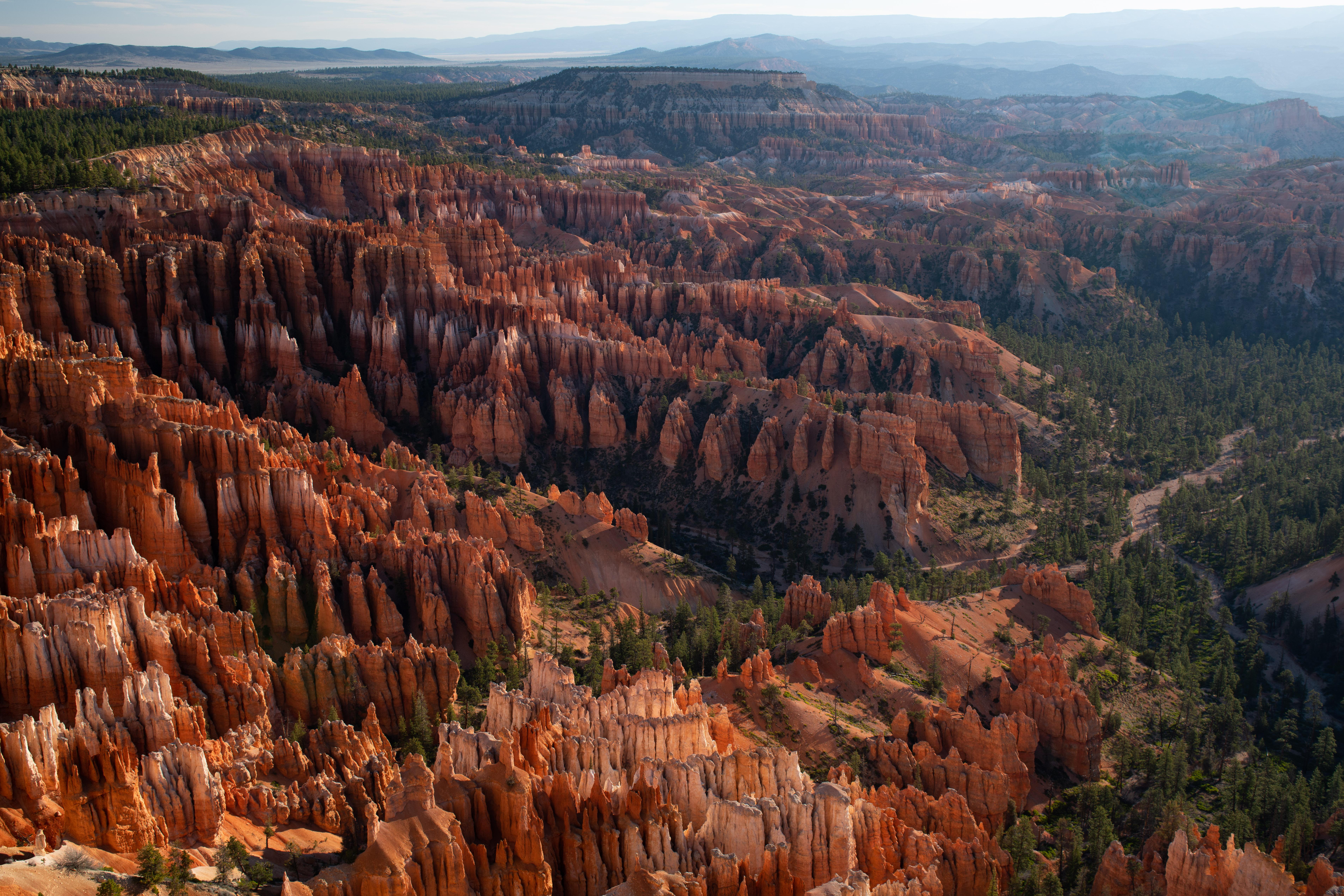
Park Overview: Cathedral Spires & Killer Floods
Zion Canyon: The Main Event
The park's heart features towering monoliths including Angel's Landing (5,790 feet), The Great White Throne (6,744 feet), and Court of the Patriarchs. The Virgin River has spent 13 million years carving through Navajo Sandstone, creating walls that rise 2,000+ feet from the canyon floor.
Kolob Canyons: The Hidden Wilderness
Northwestern section accessed via I-15, featuring finger canyons with fewer crowds but equally dangerous flash flood potential. Home to Kolob Arch, one of the world's longest natural arches at 287 feet span.
The Shuttle Prison System
March through October, private vehicles are banned from Zion Canyon. The mandatory shuttle system can trap visitors during emergencies, with no alternative evacuation routes. Plan accordingly.
Getting There & Surviving the Crowds
Access Routes
Main Entrance: UT-9 through Springdale
- From Las Vegas: 158 miles (2.5 hours) via I-15 North
- From Salt Lake City: 300 miles (4.5 hours) via I-15 South
- From Phoenix: 240 miles (4 hours) via I-17 North to UT-9
Kolob Canyons: I-15 Exit 40
- Separate entrance, different fee required
- No shuttle system, drive your own vehicle
Parking Reality Check
- Visitor Center: Fills by 7 AM in peak season
- Springdale: $20+ private lots, free shuttle to park
- Overflow Strategy: Park in Hurricane (30 minutes away) and drive in early
Entrance Fees & Permits
- Vehicle: $35 (7 days)
- Annual Pass: $70 (Zion only)
- Angels Landing: Timed permit required ($3 advance, $6 day-of)
- Narrows Top-Down: Wilderness permit required ($15)
When to Visit: Seasonal Survival Analysis
Spring (March-May): Flash Flood Season
Weather: Unpredictable storms, snowmelt increases river flow Temperatures: 60-80°F days, 40-60°F nights Dangers: Flash floods, hypothermia in water, trail closures Survival Strategy:
- Check weather upstream before entering slot canyons
- Avoid Narrows during storm warnings
- Carry warm layers for wet conditions
- River flows highest March-May from snowmelt
Summer (June-August): Furnace Mode
Weather: 100-110°F days, intense UV exposure, afternoon thunderstorms Temperatures: Canyon floor 105°F+, river provides only cooling Dangers: Heat exhaustion, dehydration, lightning in exposed areas Critical Rules:
- Start Narrows hike before 7 AM
- Exit exposed trails by 11 AM
- River temperature stays 60-70°F (hypothermia risk when overheated)
- Afternoon thunderstorms create flash flood conditions
Fall (September-November): Perfect but Crowded
Weather: Ideal hiking conditions, clear skies Temperatures: 70-90°F days, 40-70°F nights Challenges: Peak visitation, Angels Landing permits impossible to get Strategy: Book accommodations 6+ months ahead, arrive before dawn
Winter (December-February): Ice and Isolation
Weather: Snow possible, icy conditions on shaded trails Temperatures: 45-60°F days, 25-40°F nights Dangers: Hypothermia in water, icy trail conditions, limited services Advantages: Smaller crowds, drive own vehicle in canyon
Trail Guide: 17 Zion Adventures
Iconic Death-Defying Hikes
Angels Landing (Permit Required)
- Distance: 5.4 miles round trip
- Elevation Gain: 1,488 feet
- Danger Level: EXTREME (6+ deaths since 2004)
- Features: Final 0.5 miles on 18-inch wide ridge with 1,000-foot drops
- Survival Essentials: Grippy shoes, no fear of heights, turn back if chains are wet/icy
The Narrows Bottom-Up
- Distance: 9.4 miles to Big Spring (most turn around earlier)
- Water Level: Ankle to waist-deep wading entire route
- Flash Flood Risk: EXTREME - check weather forecast obsessively
- Gear Required: River shoes, walking stick, dry bag, warm layers
- Exit Strategy: No escape routes once committed - only way out is back
Family-Friendly Options
Emerald Pools Trails
- Lower Pool: 1.3 miles round trip, paved, accessible
- Middle Pool: 2.0 miles round trip, moderate difficulty
- Upper Pool: 3.0 miles round trip, steep sections
- Water Features: Seasonal waterfalls, desert oasis pools
Riverside Walk
- Distance: 2.2 miles round trip (paved)
- Difficulty: Easy, wheelchair accessible
- Features: Gateway to The Narrows, hanging gardens
- Perfect for: Kids, elderly, photography without death risk
Canyon Junction Bridge
- Distance: 0.2 miles from parking
- Features: Historic bridge over Virgin River
- Photography: Iconic Zion Canyon views
- Crowds: Extremely heavy at sunset
Moderate Adventures
Canyon Overlook Trail
- Distance: 1.0 mile round trip
- Elevation Gain: 163 feet
- Features: View of lower Zion Canyon and Pine Creek
- Best Time: Sunrise or sunset (less crowded than valley floor)
Watchman Trail
- Distance: 3.3 miles round trip
- Elevation Gain: 368 feet
- Features: Panoramic views of Zion Canyon and Springdale
- Strategy: Alternative to crowded valley floor trails
Advanced/Permit-Required Routes
The Narrows Top-Down (16-mile Wilderness)
- Distance: 16 miles one-way
- Duration: 2 days/1 night camping
- Permit: Wilderness permit required months in advance
- Danger: Complete commitment, multiple rappels, flash flood exposure
The Subway Left Fork (Bottom-Up)
- Distance: 9.5 miles round trip
- Difficulty: Technical canyoneering
- Gear Required: Ropes, rappelling equipment, advanced skills
- Permit: Wilderness permit required
Angels Landing West Rim Trail Continue
- Distance: 14.4 miles round trip total
- Extension beyond Angels Landing
- Features: Backcountry camping, primitive conditions
- Permit: Backcountry permit required for overnight
Kolob Canyons Section
Taylor Creek Trail
- Distance: 5.0 miles round trip
- Features: Historic pioneer cabins, Middle Fork Taylor Creek
- Advantages: No shuttle required, fewer crowds
- Season: Best spring and fall (summer very hot)
Kolob Arch Trail
- Distance: 14 miles round trip
- Features: One of world's longest natural arches
- Difficulty: Strenuous, full-day commitment
- Water: None available on trail
Wildlife: Desert Survivors & Dangerous Encounters
Venomous Reptiles
Great Basin Rattlesnake
- Habitat: Rocky areas, brush, shade during heat
- Activity: Dawn/dusk, avoid midday heat
- Danger Level: Potentially fatal bite
- Prevention: Watch where you step/place hands, wear boots
- Treatment: Immediate medical evacuation required
Large Mammals
Desert Bighorn Sheep
- Population: 200-300 individuals in park
- Habitat: Steep cliff faces, hard to access areas
- Viewing: Binoculars from distance only
- Behavior: Unpredictable if cornered or protecting young
- Safety: 50+ yards minimum distance
Mule Deer
- Habitat: Canyon floor, near water sources
- Risk: Aggressive during rutting season (fall)
- Disease Risk: Can carry chronic wasting disease
- Vehicle Hazard: Dawn/dusk road crossings
Dangerous Small Animals
Rock Squirrels
- Risk: Aggressive begging behavior, painful bites
- Disease: Potential bubonic plague carriers
- Never feed (federal crime with $5,000 fine)
- Food storage: Secure all items in vehicles/containers
Ringtail Cats
- Nocturnal, curious about campsites
- Risk: Food theft, potential rabies exposure
- Prevention: Proper food storage at campsites
Flash Flood Survival Protocol
Warning Signs (GET OUT IMMEDIATELY)
- Distant thunder (even if sky is clear overhead)
- Sudden increase in water level or flow
- Water changing from clear to muddy/debris-filled
- Roaring sound upstream
- Weather reports showing rain anywhere in watershed
Emergency Actions
- Exit water immediately - climb to higher ground
- Never try to outrun flood - water moves 10+ mph
- Signal for help - whistle, mirror, bright clothing
- Wait it out - floods can last hours but usually subside
- Hypothermia prevention - remove wet clothes, warm layers
Pre-Trip Planning
- Check weather for entire Virgin River watershed
- Download offline weather radar app
- Inform others of detailed itinerary
- Carry emergency communication device
Navigation & Emergency Communication
Cell Phone Coverage
- Canyon Floor: Spotty to no service
- High Points: Limited service on some viewpoints
- Emergency: 911 may work from ridge lines
- Backup Required: Satellite communicator for backcountry
GPS Navigation
- Download offline maps before entering park
- Paper backup maps essential for wilderness areas
- AllTrails Premium for detailed trail information
- Garmin inReach for emergency GPS messaging
Emergency Protocols
- Park Emergency: 911 or (435) 772-3322
- Flash Flood Warning: National Weather Service alerts
- Search & Rescue: Utah County Sheriff coordinates
- Medical Evacuation: Helicopter landing zones at major trailheads
Photography Hotspots (With Safety Notes)
Iconic Shots
Court of the Patriarchs
- Best Light: Early morning golden hour
- Safety: Stay behind barriers, crowded viewpoint
- Access: Short walk from shuttle stop
Zion Canyon from Canyon Junction Bridge
- Golden Hour: Most photographed spot in park
- Crowds: Extremely heavy at sunset
- Alternative: Early morning for fewer people
The Narrows "Wall Street"
- Location: 1.5 miles upstream from Riverside Walk
- Safety: Never enter if weather shows any chance of rain
- Gear: Waterproof camera case essential
Sunrise Locations
Watchman Trailhead
- Time: 30 minutes before sunrise
- Features: Court of the Patriarchs with morning alpenglow
- Access: No shuttle required (walk/bike from Springdale)
Canyon Overlook Trail
- Hike: 45 minutes to viewpoint
- Features: East-facing view of Zion Canyon
- Advantage: Above the crowds and shuttle system
Photography Safety Rules
- Never step backward while shooting
- Tripod mandatory near cliff edges
- Inform others when shooting alone
- Weather awareness crucial in slot canyons
- Emergency kit with whistle and first aid
Park Regulations & Emergency Costs
Critical Violations & Fines
- Angels Landing without permit: $5,000+ fine
- Feeding wildlife: $5,000 fine (federal crime)
- Entering closed areas: $500-$1,000+ fine
- Camping without permit: $200-$500 fine
- Drone operation: $1,000+ fine (completely prohibited)
Search & Rescue Costs
- Helicopter rescue: $15,000-$40,000+ (not covered by insurance)
- Technical rescue: $5,000-$20,000 depending on complexity
- Preventable incidents: May result in additional penalties
- Emergency medical: Life flight to Las Vegas trauma centers
Emergency Information
Medical Facilities
- In-Park: Basic first aid only at visitor center
- Springdale: EMT services, limited facilities
- St. George: Dixie Regional Medical Center (45 minutes)
- Las Vegas: Major trauma centers (2.5+ hours)
Emergency Contacts
- Park Emergency: 911 or (435) 772-3322
- Flash Flood Hotline: (435) 772-0971
- Visitor Center: (435) 772-3256
- Backcountry Desk: (435) 772-0170
Common Fatal Incidents
- Flash flood drownings in slot canyons
- Falls from Angels Landing chains section
- Heat exhaustion/dehydration on exposed trails
- Hypothermia from wet clothing in cold conditions
- Rock falls in narrow canyon sections
Insider Survival Wisdom
- Flash Flood Reality: More people die from drowning than falling
- Shuttle Dependency: System shuts down in emergencies - plan exit routes
- River Temperature: Stays cold year-round (hypothermia risk when overheated)
- Angels Landing: Turn back if chains are wet, icy, or crowded
- Weather Obsession: Check conditions 100+ miles upstream
- Crowd Timing: Start hiking before 7 AM or accept massive crowds
- Water Strategy: River water requires purification - carry backup
- Emergency Position: High ground always better than low ground
- Permit Reality: Popular permits sell out in minutes
- Exit Plan: Always have multiple escape routes planned
Final Survival Wisdom
Zion's towering beauty conceals deadly reality. These ancient sandstone cathedrals have witnessed flash floods that kill in minutes and cliff falls that claim lives annually. The Virgin River that created this masterpiece continues to carve—and kill. Every narrow slot canyon is a potential death trap when storm clouds gather anywhere in the 9,000-square-mile watershed. Come prepared for the desert's extremes, respect the flash flood danger, and understand that the same forces that created this wonder can destroy the unprepared. Your survival depends on constant weather awareness, proper gear, and the wisdom to turn back when conditions deteriorate. In Zion, the difference between an epic adventure and a tragedy is often measured in minutes of warning before the flood arrives.
Real satellite imagery on NASA elevation — orbit the peaks at true scale.
Explore in 3D →Trails worth your morning.
Distance and difficulty for the well-known routes — verify current conditions at the visitor center on arrival.
What the park will quietly do to you.
Heat & Sun
SummerSummer highs can hit 100°F+ in many western parks. Carry 2 L of water per person minimum and avoid strenuous activity 10am–4pm.
Wildlife
Year-roundKeep 100 yards from bears and wolves, 25 from everything else. Never feed wildlife — it changes their behavior and ends with the animal euthanized.
Weather windows
SummerHigh-country thunderstorms build fast in summer afternoons. Plan to be off exposed ridges by noon, especially July–September.
Permits & timed entry
Plan aheadSeveral parks require timed-entry reservations or wilderness permits. Reserve weeks ahead via recreation.gov — same-day windows are limited.
Hero photo: NPS/Shane Carte